Sold1860 WALL MAP OF PHILIADELPHIA CAMDEN & VICINITYLake and Beers surveyor, published by Stone & Pomeroy 1860, measures 64 by 62, somewhat frail but displayable.See Sold Price
Sold1860 WALL MAP OF NYC NEW YORKMap of New York and its Environs. H.F. Walling, published by S.D. Tilden 1860. Dimensions: (Open) H 64" x W 64" Condition: Separated from wooden rolled. Signs of age including losses, crazing, bendingSee Sold Price
Sold1860 WALL MAP OF NEW JERSEY, WILLIAM KITCHELL1860 WALL MAP OF NEW JERSEY, WILLIAM KITCHELL, 71" X 58 1/2"See Sold Price
Sold1860 wall map of sussex, county - new jerseyDescription: Gm. hopkins, carlos allen, md. publishers - from the estate of richard "dick" roy Condtion: Bottom wooden support is detached - some staining and discoloration Size: 52" X 56" Consignor:See Sold Price
Sold1860 J.H. French wall map of New York State1860 J.H. French wall map of New York State w. 73" - AS IS, significant damage and losses to upper portionSee Sold Price
New York & Long Island Wall Map, 1901New York and vicinity wall map by Rand McNally, 1901. Displayed in a wood frame and ultra clear plexiglass. Dimensions: 46" L x 52" W x 1.5" HSee Sold Price
SoldA 'LLOYD'S AMERICAN RAILROAD WALL MAP' DATED 1860The hand colored 'Lloyd's Map of the Eastern States' copyright dated 1860 upper right, labeled railway routes for a variety of small and large railroads, an inset of Texas railroads and a time conversSee Sold Price
Large wall map of San Jose & vicinity 1905Heading: (California - San Jose) Author: MacMillan, J.G. Title: 1905 Map of the city of San Jose and vicinity, compiled from official records Place Published: [San Jose, Calif.?] Publisher: DateSee Sold Price
Large wall map of San Jose & vicinity 1905Heading: (California - San Jose) Author: MacMillan, J.G. Title: 1905 Map of the city of San Jose and vicinity, compiled from official records Place Published: [San Jose, Calif.?] Publisher: DateSee Sold Price
SoldLarge wall map of San Jose & vicinity 1905Heading: (California - San Jose) Author: MacMillan, J.G. Title: 1905 Map of the city of San Jose and vicinity, compiled from official records Place Published: [San Jose, Calif.?] Publisher: DateSee Sold Price
Large wall map of San Jose & vicinity 1905Heading: (California - San Jose) Author: MacMillan, J.G. Title: 1905 Map of the city of San Jose and vicinity, compiled from official records Place Published: [San Jose, Calif.?] Publisher: DateSee Sold Price
1860 Andriveau Goujon Folding Wall Map of Paris, FranceThis is a beautiful map of Paris created by Andriveau-Goujon’ with their distinctive pastel coloring to show the expansion works of . It was published in 1860 and is one of the earliest modern mSee Sold Price
Sold[U.S. WALL MAP]. [United States]. Ca.1860 (Ne[U.S. WALL MAP]. [United States]. Ca.1860 (Nebraska and Minnesota territories shown, and presidential vignettes through James Buchanan). Approx 24 x 56, half of that with portraits of each president aSee Sold Price
Two Connecticut Hanging Wall Maps, 19th C.Smith's wall map of Hartford County, Philadelphia 1858, and Clark and Tackabury's topographical wall map of Connecticut, Philadelphia 1860. Each in fair to poor condition with staining, discoloration,See Sold Price
SoldANTIQUE WALL MAP OF NEW YORK FROM 1860 (3256)Antique wall map of New York from 1860 laminated with wood rod top. 70"H x 70"W. C.1860. Material: laminated paper with wood rodSee Sold Price
Wall Map of York County, Pennsylvania. 1860.[America/ Pennsylvania] Shearer, W.O. “Shearer’s Map of York County Pennsylvania.” W.O Shearer & D.J. Lake, Philadelphia, 1860. Lithograph map: 59 3/4” x 62”. Framed: 63See Sold Price
Wall Map of York County, Pennsylvania. 1860.[Pennsylvania] Shearer, W.O. Shearer’s Map of York County Pennsylvania. W.O Shearer & D.J. Lake, Philadelphia, 1860. Lithograph map. 59 3/4” x 62”. Framed: 63” x 64 1/2”See Sold Price
SoldWall map of Lebanon Co., PAca. 1860; by H.F. Bridgens, showing roads, streams, municipal boundaries & property owners, paper on linen, wooden hanging rods, 61"x 60";See Sold Price
SoldWall Map of Nevada City & Grass Valley CA 1877Title: Map of the Vicinity of Grass Valley and Nevada City, Nevada County, California. Compiled from U.S. Government Surveys and Personal Observations in the Field Author: Uren, Charles E. DescriptionSee Sold Price
SoldMitchell Wall Map of AmericaMitchell’s National Map of the American Republic. Samuel Augustus Mitchell (1790-1860). Engraved map with original hand color in full. Philadelphia, 1843. 41 x 48 inches sheet, 48 x 55 inches framedSee Sold Price
Large wall map of towns south of Oakland, CAHeading: (California - Alameda County) Author: Title: Thomas Bros. Map of Richmond, El Cerrito, San Pablo, and vicinity Place Published: Oakland Publisher:Thomas Bros. Date Published: c.1938See Sold Price
Large wall map of towns south of Oakland, CAHeading: (California - Alameda County) Author: Title: Thomas Bros. Map of Richmond, El Cerrito, San Pablo, and vicinity Place Published: Oakland Publisher:Thomas Bros. Date Published: c.1938See Sold Price
Two 19th C. Hanging Wall Maps, NY & PennsylvaniaBeers Lake and Beers wall map of Columbia County, NY, Philadelphia,1858, and Smith, Gallup and Co. wall map of Northampton County, PA, Philadelphia, 1860. Each in fair to poor condition with staining,See Sold Price
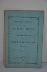
Central Railroad of New Jersey 13th Annual Report-January 1, 1860JM Hobby Supply and Railroad Artifact Auctions4.4(126)See Sold PriceFeb 24, 2024
Two Michigan Central RR Annual Reports-June 1860 and December 31, 1897JM Hobby Supply and Railroad Artifact Auctions4.4(126)See Sold PriceFeb 24, 2024
1892 Adams and Bowles New Road Map of the State of New YorkJM Hobby Supply and Railroad Artifact Auctions4.4(126)See Sold PriceFeb 24, 2024
Cincinnati Hamilton and Dayton RR Map -USGC 1889JM Hobby Supply and Railroad Artifact Auctions4.4(126)See Sold PriceFeb 24, 2024
FLYING A TOURING SERVICE U.S. ROAD MAPS TIN WALL DISPLAY.Dan Morphy Auctions4.2(1.3k)See Sold PriceFeb 25, 2024
MAP - Dufour, A. H. ( Malte / Brun ) :MAP - ESPAGNE PARTIE SUD DIVISEE EN PROVINCES ANCIENNES ( MAPLuis Porretta Fine Arts4.3(10)See Sold PriceMar 02, 2024
Medieval Printed Paper Bible Page by Johann GrüningerTimeLine Auctions Ltd.4.5(183)See Sold PriceMar 07, 2024
Illustrated Sabbath Cloth - Holy Sites of Eretz IsraelLevy Auction House4.3(11)See Sold PriceFeb 27, 2024
Vintage Full Color World Map LithographThe Benefit Shop Foundation Inc.4.3(2.9k)See Sold PriceFeb 28, 2024
Vintage County Map Of NY State Plate EngravingThe Benefit Shop Foundation Inc.4.3(2.9k)See Sold PriceFeb 28, 2024
Portfolio of 15 County Maps by Robert Morden (English 1650-1703)Nadeau's Auction Gallery4.7(401)See Sold PriceFeb 24, 2024
Vintage Vanguard Studio wall map, dated 1968South Jersey Auction by Babington Auction Inc4.6(122)See Sold PriceFeb 25, 2024
Vintage Framed Pine Island & Lacoste Island MapThe Benefit Shop Foundation Inc.4.3(2.9k)See Sold PriceMar 06, 2024
ALPHONSE MUCHA (1860-1939) [BYZANTINE & LANGAGE DES FLEURS] / ALBUM DE LA DÉCORATION. 1900.Swann Auction Galleries4.4(65)See Sold PriceFeb 29, 2024
3 Vintage The World Lithographs, By JanssonThe Benefit Shop Foundation Inc.4.3(2.9k)See Sold PriceMar 13, 2024
Two Hand-Colored 19th Century Maps of New Orleans and Louisiana, Larger- H.- 12 1/2 in., W.- 15 1/2Crescent City Auction Gallery4.3(229)See Sold PriceMar 08, 2024
Vintage 1920s Rand McNally Auto Trails MapThe Benefit Shop Foundation Inc.4.3(2.9k)See Sold PriceMar 20, 2024
Lalique, René: Masque de FemmePeter Karbstein Kunst und Auktionshaus4.2(9)See Sold PriceMar 16, 2024


![[U.S. WALL MAP]. [United States]. Ca.1860 (Ne (1 of 1)](https://p1.liveauctioneers.com/179/10971/2682777_1_x.jpg?height=282&quality=70&version=1162265652)


![ALPHONSE MUCHA (1860-1939) [BYZANTINE & LANGAGE DES FLEURS] / ALBUM DE LA DÉCORATION. 1900. (1 of 2)](https://p1.liveauctioneers.com/199/319703/171640482_1_x.jpg?height=282&quality=70&version=1707943705)