Poster "Les jardins de Paris", illustrated map and plan of Paris with its parcs, gardens, monuments,Proverde Auctions4.3(3)See Sold PriceFeb 28, 2024
WEST CENTRAL AFRICA. Congo Angola Gabon Cameroon Sao Tome. MALLET 1683 old mapJasper524.5(9.8k)See Sold PriceFeb 28, 2024
1859 Map of AustraliaTitle: 1859 Map of Australia Author: Chambers Medium: Ink on Paper Dimensions: 11.5"X9.5" Description: Map of Australia and East Indies dated 1859. Part of the Modern & Ancient Geography Atlas. EngravSee Sold Price
1859 Map of Australia and East IndiesTitle: 1859 Map of Australia and East Indies Author: Chambers Materials: Ink on Paper Dimensions: 11.5"X9.5" Description: Map of Australia and East Indies dated 1859. Part of the Modern & Ancient GeogSee Sold Price
1859 Australia Map by ColtonTitle: 1859 Australia Map by Colton Date/Period: 1859 Materials: Hand colored steering engraved Size: 17 1/2 x 14 1/2” This hand-colored, steel-engraved map of Australia predates the establishmeSee Sold Price
Colton: Antique Map of Australia, 1859Title/Content of Map: Australia by Colton Date: 1859 Cartographer: H.J. Colton Size: 17 1/2" x 15" Hand colored and engraved. Published in New York in Colton's 'General Atlas'. Please note that this lSee Sold Price
Colton: Antique Map of Australia, 1859Title/Content of Map: Australia by Colton Date Printed: 1859 Cartographer: H.J. Colton Material/Medium: Paper Size: 14" x 17" Provenance: New York Hand colored engraved Map. Published in New York in 'See Sold Price
Colton: Antique Map of Australia, 1859Title/Content of Map: Australia by Colton Date Printed: 1859 Cartographer: H.J. Colton Material/Medium: Paper Size: 17 1/2" x 15" Hand colored engraved Map. Published in New York in 'Colton's GeneralSee Sold Price
SoldAUSTRALIA. no Queensland (est 1859). ShowingTITLE/CONTENT OF MAP: 'Australia' Goldfields are marked in yellow. Vignettes: Natives of the tribe of Bogan; Sydney; kangaroos; Australian parrots and Cockatoo; Natives of Australia Felix. The countieSee Sold Price
SoldAUSTRALIA. no Queensland (est 1859). ShowingTITLE/CONTENT OF MAP: 'Australia' Goldfields are marked in yellow. Vignettes: Natives of the tribe of Bogan; Sydney; kangaroos; Australian parrots and Cockatoo; Natives of Australia Felix. The countieSee Sold Price
AUSTRALIA. no Queensland (est 1859). ShowingTITLE/CONTENT OF MAP: 'Australia' Goldfields are marked in yellow. Vignettes: Natives of the tribe of Bogan; Sydney; kangaroos; Australian parrots and Cockatoo; Natives of Australia Felix. The countieSee Sold Price
Tallis/Rapkin: Map of Australia, Pre-Queensland, 1849Map: 'Australia. Sydney view. Pre-Queensland (est 1859). Counties'. Vignettes: Natives of the tribe of Bogan; Sydney; kangaroos; Australian parrots and Cockatoo; Natives of Australia Felix. The countiSee Sold Price
The World on Mercator's Projection by John Bartholomew 1859 old antique mapCAPTION PRINTED BELOW PICTURE: 'The World on Mercator's Projection' Small fragments of the Antarctic coast are shown. The antipodes are named as "New Holland or Australia", while the islands of New ZeSee Sold Price
AUSTRALIA. no Queensland (est 1859). Showing Goldfields. TALLIS/RAPKIN 1851 mapTitle: AUSTRALIA. no Queensland (est 1859). Showing Goldfields. TALLIS/RAPKIN 1851 map Description: Australia' by Map drawn and engraved by J. Rapkin; vignette illustrations drawn by J Marchant & engrSee Sold Price
AUSTRALIA. no Queensland (est 1859). Showing Goldfields. TALLIS/RAPKIN 1851 mapTitle: AUSTRALIA. no Queensland (est 1859). Showing Goldfields. TALLIS/RAPKIN 1851 map Description: Australia' by Map drawn and engraved by J. Rapkin; vignette illustrations drawn by J Marchant & engrSee Sold Price
Australia; Notes Taken During A Residence In The...Australia; Notes Taken During A Residence In The Colonies From The Gold Discovery In 1851 Till 1857 by P Just 1859 Book - A 328 page book with One Plate and Map. Has interesting chapters about developSee Sold Price
SoldTallis, John (Pub) 1852 Map. AustraliaSteel Engraved Map with Original Outline Hand Color Published 1852-56 by John Tallis, London for "The Universal Pronouncing Dictionary" by Thomas Wright. Drawn & Engraved by John Rapkin. Centre fold aSee Sold Price
Sold1859 Map of PalestineTitle: 1859 Map of Palestine Author: Chambers Medium: Ink on Paper Dimensions: 9.5"X11.5" Description: Map of Palestine dated 1859. Part of the Modern & Ancient Geography Atlas. Engraved by J.GellatlySee Sold Price
SoldAntique 1859 Map of Kendall County IllinoisBy L. J. Bennett, 45 x 51 inches some damageSee Sold Price
Sold1859 Map of Ancient GreeceTitle: 1859 Map of Ancient Greece Author: Chambers Medium: Ink on Paper Dimensions: 9.5"X11.5" Description: Map of Ancient Greece dated 1859. Part of the Modern & Ancient Geography Atlas. Engraved bySee Sold Price
Sold1859 Map of MexicoTitle: 1859 Map of Mexico Author: Johnson Medium: Ink on Paper Dimensions: 18"x14" Map of Mexico dated 1859. Engraved by A.J. Johnson. Published by Johnson and Ward in New York. Johnson is consideredSee Sold Price
Sold1859 Map of the USTitle: 1859 Map of the US Author: Chambers Medium: Ink on Paper Dimensions: 11.5"X9.5" Description: Map of the United States dated 1859. Part of the Modern & Ancient Geography Atlas. Engraved by J.GelSee Sold Price
SoldJ.H. COLTON'S 1859 MAP OF MIDWESTERN STATESThe full title of this map is “Guide Through Ohio, Michigan, Indiana, Illinois, Missouri, Wisconsin, Iowa, Minnesota, Nebraska & Kansas Showing the Township lines of the United States Surveys, LocatSee Sold Price
SoldLevasseur, Victor 1859 Map of Senegal, Madagascar"Colonies Francaises en Afrique" Steel Engraved Map Published 1859, Paris for "Atlas National Illustre" by Victor Levasseur. Paper Size: 20.5 x 14.5 inch (52 x 37cm) Good ConditionSee Sold Price
SoldLevasseur, Victor 1859 Map of Guadeloupe. Caribbean"Colonies Francaises en Amerique" Steel Engraved Map Published 1859, Paris for "Atlas National Illustre" by Victor Levasseur. Paper Size: 20.5 x 14.5 inch (52 x 37cm)See Sold Price
1859 Map of CanadaTitle: 1859 Map of Canada Author: Chambers Medium: Ink on Paper Dimensions: 11.5"X9.5" Description: Map of Canada dated 1859. Part of the Modern & Ancient Geography Atlas. Engraved by J.Gellatly. PublSee Sold Price
EARLY 18TH C. DUTCH CHART OF PACIFIC OCEAN BY FREDERIK DE WIT (1629-1706) WITH CALIFORNIA AS ANThomaston Place Auction Galleries4.4(386)See Sold PriceFeb 24, 2024
D'Entrecasteaux - Australia: Coasts of Van Diemen's Land (New Holland). 9Trillium Antique Prints & Rare Books4.5(30)See Sold PriceFeb 24, 2024
D'Entrecasteaux - Tasmania, Australia: Map of the Northern Portion of Recherche Bay. 5Trillium Antique Prints & Rare Books4.5(30)See Sold PriceFeb 24, 2024
D'Entrecasteaux - Australia: Chart of Van Diemen's Land (New Holland). 3Trillium Antique Prints & Rare Books4.5(30)See Sold PriceFeb 24, 2024
D'Entrecasteaux - Map of Australia (New Holland), New Zealand, and southern Asia and surroundingTrillium Antique Prints & Rare Books4.5(30)See Sold PriceFeb 24, 2024
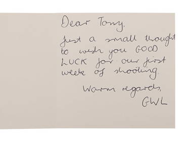
STAR WARS: ATTACK OF THE CLONES (2002) - Anthony Daniels Collection: Handwritten Note to AnthonyPropstore4.2(6)See Sold PriceMar 13, 2024
Western Africa by Edward Weller. Early British/French settlements 1859 old mapJasper524.5(9.8k)See Sold PriceFeb 28, 2024
2019 Australia 1 oz Silver $5 Map of the World PR-70 PCGS (FS)Golden Gate Auctioneer4.1(273)See Sold PriceFeb 27, 2024
2019 Australia 1 oz Silver $5 Map of the World PR-70 PCGS (FS)Golden Air Auctions4.4(257)See Sold PriceFeb 28, 2024
James Cook - Antique map Australia titled 'Gezigt van het Eil. Suffren'. Antique map of SuffrenProverde Auctions4.3(3)See Sold PriceFeb 28, 2024
Vintage Australia Airplane Ashtray [Kangaroo]Grant Zahajko Auctions, LLC4.8(1k)See Sold PriceMar 06, 2024


![Vintage Australia Airplane Ashtray [Kangaroo] (1 of 7)](https://p1.liveauctioneers.com/5755/320282/172113950_1_x.jpg?height=282&quality=70&version=1708463029)


