Sold17th Century Map of FranceMap titled "Le Gouvernement de l'Isle de France Par Damien de Templeux Escuyes Sr. du Frestoy." showing central portion of France including Paris. Map by Bleau, c.1640's. Map is hand colored, measuresSee Sold Price
SoldDecorative Framed 17th/18th Century Hand-coloredDecorative Framed 17th/18th Century Hand-colored Map of France, depicting "Le Gouvernement de L'Isle de France."See Sold Price
SoldAn 18th Century Map of Poland,Guillaume De L'Isle, published paris, c.1702, with cartouche which reads 'La Pologne Dressee sur ce qu'en ont donne Starovolsk, Beauplan, Hartnoch . . .', copper engraving, uncoloured, verso plane, diSee Sold Price
SoldA Large 18th Century Map of Poland,published in Paris, C.1738, Guillaume De l'Isle's (1675-1726), cartouche reads 'La Pologne. Chez l’Auteur sur le Quai de l’Horloge a la C. ne de Diamãs. Avec Privilege du Roy, et se tSee Sold Price
SoldMercator. 17th C. map of FranceMercator. L'Isle De France. Parisiensis Agri Descrip. Ca.1630. Double-page engraving, contemporary hand-coloring. 13 1/8 x 18 1/8 in., Latin text on verso. Upper right corner of margin detached but pSee Sold Price
Sold(2) 18TH CENTURY FRENCH & GERMAN MAPS(lot of 2) Maps; (1) framed map from the "Atlas Universal" by Gilles Robert de Vaugondy and son (France, c.1723-1786), entitled "Gouvernement General de L'Isle de France, divise par Pays, Par le Sr. RSee Sold Price
SoldBlaeu (J & W) Le l'Isle de FranceBlaeu (J & W) Le l'Isle de Francenorth central region of France including Paris, large decorative cartouches, engraved map with original hand-colouring, 410 x 520mm., [Amsterdam], [c.1640] DSee Sold Price
Abraham Ortelius (1527-1598)Lot 340 Abraham Ortelius (1527-1598) L'ISLE DE FRANCE | PARISIENSIS AGRI DESCRIP. copper engraved map of Paris and its environs published in Amsterdam, c.1600 sheet 18 x 22.,5 in — 45.7 x 57.2 cm; 2See Sold Price
SoldJEAN PRUTHENUS SOMER - Les Isles CanariesJEAN PRUTHENUS SOMER sculpit from France 17th century PIERRE DUVAL invent. France 1619 - 1683 Les Isles Canaries. Paris, 1653 Colored etching Signed, titled and dated Sizements 34 x 51.5 cm From the wSee Sold Price
SoldMap, Isle De France, Champagne, 1648MAP. Du Roy, George, Isle de France, Champagne, Lorraine & c., 1648, R. Cordieier Abbauil Sculpt., hand colored, 14 1/4" h x 23" w. Condition: foxing and loss on margin, minor staining.See Sold Price
Sold17th Century Map of Northern ScotlandMap titled "Isle De Fero de Scheland Orknay et Hebrides" by Alain Manesson Mallet, Frankfurt ,1686. Framed map measures 5.75" x 4.25" (sight). Map exhibits extensive hand coloring. Frame measuresSee Sold Price
SoldA 17th Century Map of Poland, lithuania, Ukraine,Johannes de Ram, c.1690, titled 'Regni Poloniae et Ducatus Lithuaniae Volhyniae, Podoliae, Ucraniae, Livoniae et Curlandiae, Descriptio, Ementata de Johannes de Ram', Copperplate engraving original unSee Sold Price
Sold(MAP) BELLIN, NICHOLAS. Carte reduite du Golphe du(MAP) BELLIN, NICHOLAS Carte reduite du Golphe du Mexique et des isles de l'Amerique. Paris, c. 1764. Engraved map with hand-coloring. Framed and matted. 21 x 31 1/4 inches.See Sold Price
SoldA 17th century map of Scotland (Escosse sic), takenA 17th century map of Scotland (Escosse sic), taken from A M Mallet, Description de L'Univers, Paris, 1683, 21cm x 14cm overall, and a hand tinted 18th century map of Scotland, c1762, 22cm x 19.5cm xSee Sold Price
de Wit: Antique Dutch Map of Italy, 1680Title: Novissima et Accuratissima totius Italiae Corsicae et Sardiniae Descriptio. Lovely 17th century Dutch map of Italy Map maker: Frederick de Wit Place and Year: Amsterdam, c. 1680 Dimensions: 56.See Sold Price
SoldJansson (Jan) Gouvernement de l'Isle de FranceJansson (Jan) Gouvernement de l'Isle de France,map showing Ile-de-France, including Paris, cartouche upper right, engraved map with hand colouring, 380 x 500mm, central vertical fold, some spoSee Sold Price
SoldTwo Maps by Nicolas Sanson (1600-1667, Paris), "Isle deTwo Maps by Nicolas Sanson (1600-1667, Paris), "Isle de France, Champagne, Lorraine," 1679; together with "Le Royaume de France, Toutes ses Provinces, et ses Acquisitions, L'Espagne le Luxembourg," 16See Sold Price
SoldAmerican School, 19th c. Woman in Interior, oilOil on canvas, possibly signed "F.T. More" lr, inscribed "Fontainbleau, Paris, France 17th century, siecle" on stretcher on verso, 23 x 18 in., framed; Estate of Jerry Ulin, Coleman and May AntiquesSee Sold Price
SoldMap: Duche De Bretaigne, 17Th C, HC EngravingTitle: Map: Duche de Bretaigne, Printmaker: Joannus Jansson, Date: 17th Century, Medium: Hand-colored engraving, Sight size: 16 1/4 x 21 1/2, Inscribed: Engraver identified within matrix, Condition: GSee Sold Price
SoldFour 17th Century British Isles Maps,Four 17th Century British Isles Maps, all ca. 1650s, as follows: "Aebudae Insulae Sive Hebrides...The Western Isles of Scotland," Timothy Pont, published by Joan Blau, Amsterdam, (SS:15" x 21"); "EpisSee Sold Price
SoldCruise Ship Silverplate Trophy GroupOriginal Silver plate loving cup or Trophy group First and Second Quarter 20th Century. Includes: Holland America, SS Paris, SS Isle De France, AA Atlantic Home Lines, Souvenir of Savannah Line City oSee Sold Price
SoldFrères Ornithological Paris Porcelain PlatesA Good Pair of Darte Frères Ornithological Paris Porcelain Cabinet Plates , c. 1825, the centers depicting hand-painted specimens of "Momot, du Brésil, mâle", and "Guêpier de l'Isle de France, féSee Sold Price
SoldGroup of French Maps Guillaume de l'Isle SansonGroup of four 17th and 18th century French maps. Guillaume Delisle (1675-1726) hand colored engraved map of Picardie, 1748. Two maps by Nicolas Sanson (1600-1677), "Le Roayaume de France" and "GouvernSee Sold Price
LARGE LATE 17TH C. DUTCH CHART OF CANADA, GREAT LAKES, NEW FRANCE, LABRADOR, HUDSON BAY, BY PIERREThomaston Place Auction Galleries4.4(389)See Sold PriceFeb 24, 2024
LATE 17TH C. FRENCH MAP OF THE NEW WORLD BY ALEXIS-HUBERT JAILLOT (1632-1712)Thomaston Place Auction Galleries4.4(389)See Sold PriceFeb 24, 2024
17TH C. ANTIQUE MAP SIEGE OF LA ROCHELLE, FRANCE, FRAMEDThomaston Place Auction Galleries4.4(389)See Sold PriceFeb 24, 2024
D'Entrecasteaux - Australia: Coasts of Van Diemen's Land (New Holland). 9Trillium Antique Prints & Rare Books4.5(30)See Sold PriceFeb 24, 2024
D'Entrecasteaux - Tasmania, Australia: Map of the Northern Portion of Recherche Bay. 5Trillium Antique Prints & Rare Books4.5(30)See Sold PriceFeb 24, 2024
D'Entrecasteaux - Australia: Chart of Van Diemen's Land (New Holland). 3Trillium Antique Prints & Rare Books4.5(30)See Sold PriceFeb 24, 2024
D'Entrecasteaux - Map of Australia (New Holland), New Zealand, and southern Asia and surroundingTrillium Antique Prints & Rare Books4.5(30)See Sold PriceFeb 24, 2024
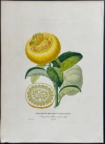
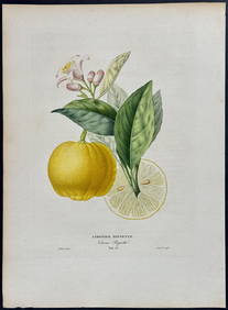
Risso - Lemon or Citrus Fruit. 73Trillium Antique Prints & Rare Books4.5(30)See Sold PriceFeb 24, 2024
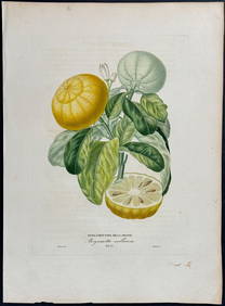
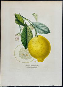
Risso - Lemon or Citrus Fruit. 71Trillium Antique Prints & Rare Books4.5(30)See Sold PriceFeb 24, 2024
1758 MAP PARTIE DE LA MER GLACIALE contenants La Nouvelle Zemble RUSSIA antiqueJasper524.5(9.8k)See Sold PriceFeb 27, 2024
1749 MAP CARTE DE LA TARTARIE ORIENTALE RUSSIA & CHINA antique EASTERN TARTARYJasper524.5(9.8k)See Sold PriceFeb 27, 2024
1760 MAP CARTE PARTICULIERE DE L'ISLE DE JUAN FERNANDES antique Robinson CrusoeJasper524.5(9.8k)See Sold PriceFeb 27, 2024
Jules Verne, Le Testament d'un Excentrique, Aux HarponsLion and Unicorn4.8(1.9k)See Sold PriceMar 03, 2024
NICOLAS LEMERY'S 1717 PHARMACOPEIA IS AN OLD FRENCH PHARMACOLOGY TREATISE FROM THE 17TH CENTURY.NY Elizabeth 4.3(85)See Sold PriceMar 03, 2024
FRENCH ANTIQUE FOLIO TITLED "HISTORY OF CHARLES VIII, KING OF FRANCE" (1684) BY G. JALIGNYNY Elizabeth 4.3(85)See Sold PriceMar 03, 2024
Denis Diderot (1713 - 1784) & Jean Le Rond d’Alembert (1717 - 1783) - Set of 10 Military Prints -Proverde Auctions4.3(3)See Sold PriceFeb 28, 2024
Denis Diderot (1713-1784) & Jean Le Rond d’Alembert - Set of 10 Military Prints - Empty frame [forProverde Auctions4.3(3)See Sold PriceFeb 28, 2024
Jules Verne, L'Etoile du Sud, Au Steamer Red MacaronLion and Unicorn4.8(1.9k)See Sold PriceMar 10, 2024
16TH AND 17TH CENTURY MEDICAL WORKS. A group of early publications on medicine and surgery.Bonhams4.1(315)See Sold PriceJun 18, 2024