2 Illuminated Books of Hours LeavesSchmidt's Antiques Inc. Since 19114.8(431)See Sold PriceMar 02, 2024
Illuminated Manuscript Leaf of The CrucifixionSchmidt's Antiques Inc. Since 19114.8(431)See Sold PriceMar 02, 2024
RARE 1930s AUTOGRAPH BOOK FEATURING RUTH & GEHRIGJohn McInnis Auctioneers,LLC4.5(505)See Sold PriceFeb 25, 2024
Timetable, Paper and Ephemera Lot-Eastern USA RailroadsJM Hobby Supply and Railroad Artifact Auctions4.4(127)See Sold PriceFeb 24, 2024
SCARCE 1971 Kim Il Sung Signed Book "ON THE WORK OF THE WOMAN'S UNION"Rbfinearts4.5(578)See Sold PriceFeb 24, 2024
1885 CIVIL WAR 1ed Famous Memoirs US Grant Sheridan Sherman 6v RARE LOT MapsSchilb Antiquarian Rare Books4.8(428)See Sold PriceMar 10, 2024
"WINTER AND SUMMER IN MAINE" 1904 PHOTO ALBUMJohn McInnis Auctioneers,LLC4.5(505)See Sold PriceFeb 25, 2024
1821 THE (3) VOYAGES of CAPT JAMES COOK VOL. I-VIIJohn McInnis Auctioneers,LLC4.5(505)See Sold PriceFeb 24, 2024
[BASEBALL]. [SHEET MUSIC]. KALBFLEISCH, J. H. The Live Oak ...Potter & Potter Auctions4.6(545)See Sold PriceMar 07, 2024
Illuminated Manuscript Leaf of The VisitationSchmidt's Antiques Inc. Since 19114.8(431)See Sold PriceMar 02, 2024
Illuminated Manuscript Leaf of GethsemaneSchmidt's Antiques Inc. Since 19114.8(431)See Sold PriceMar 02, 2024
c1700s RARE Arabic Handwritten Manuscript Middle East Persia Journal ARABIASchilb Antiquarian Rare Books4.8(428)See Sold PriceMar 10, 2024
Sold1799 Antique Geographical Dictionary Fold Out World Map1799 Antique Geographical Dictionary In French With Fold Out Map Of The World. Volume 1. Printed In Bruxelles. Good Condition, Some Foxing, Some Wear Of The Binding. Size 8 By 5" Please note that thisSee Sold Price
SoldBrookes, Richard 1807 Map of World HemispheresCopper Engraved Map Published 1807, London for "The General Gazetteer; Or, Compendious Geographical Dictionary" by Richard Brookes. Engraved by B. Baker. Folds as issued. Paper Size: 12 x 8 inch (30 xSee Sold Price
SoldA COMPLETE PRONOUNCING GAZETEER OR GEOGRAPHICALA COMPLETE PRONOUNCING GAZETEER OR GEOGRAPHICAL DICTIONARY OF THE WORLD . THOMAS, J. & BALDWIN, T. Philadelphia: J. B. Lippincott & Co., 1866; Lg. 8vo,. 2317pp, Full tan leather w/unmarked off-color bSee Sold Price
SoldGuthrie, William 1799 Antique Map of RussiaCopper Engraved Map Published 1799, London for "A New Geographical, Historical and Commercial Grammar..." by William Guthrie. The maps are by D. Ogilby & Son and others. Folds as issued. Paper Size: 1See Sold Price
SoldWilliam Guthrie A NEW GEOGRAPHICAL HISTORICAL ANDWilliam Guthrie A NEW GEOGRAPHICAL HISTORICAL AND COMMERCIAL GRAMMAR AND PRESENT STATE OF THE SEVERAL KINGDOMS OF THE WORLD 1787 Antique Leatherbound Engraved Fold-Out Maps Complete Tables AstronomicaSee Sold Price
Sold1795 Geographical Dictionary & Geographical Grammer-1795 Geographical Dictionary & Geographical Grammer- both with fold-out mapsSee Sold Price
Antique Geographical Map of the World, 1820Title/Content of Map: Geographical Map of the World, With the Traces of The Most Celebrated Navigators, for The Elucidadion [Sic] Of Lavoisne's Genealogical Historical, Chronological, and GeographicalSee Sold Price
SoldBohun (Edmund) A Geographical DictionaryBohun (Edmund) A Geographical Dictionary, second edition, title in red and black, additional engraved title, full-page engraved twin-hemisphere world map to verso of A8 and 4 folding engravedSee Sold Price
Sold1833 Davenport Gazetteer of N. America w/foldout mapsA New Gazetteer or Geographical Dictionary of North America and the West Indies, etc. Original full calf. Gilt-decorated spine with label. Illustrated with two fully hand-colored, foldout maps and manSee Sold Price
1833 Davenport Gazetteer of N. America w/foldout mapsA New Gazetteer or Geographical Dictionary of North America and the West Indies, etc. Original full calf. Gilt-decorated spine with label. Illustrated with two fully hand-colored, foldout maps and manSee Sold Price
Sold3V EARLY GEOGRAPHY HISTORY Longman McCullochThis auction lot includes the following group of titles: - McCulloch's Geographical Dictionary by McCulloch - Dated 1896 by Longmans - 2V library binding, foldout maps - Longman's Gazetteer of theSee Sold Price
1833 Davenport Gazetteer of N. America w/foldout mapsA New Gazetteer or Geographical Dictionary of North America and the West Indies, etc. Original full calf. Gilt-decorated spine with label. Illustrated with two fully hand-colored, foldout maps and manSee Sold Price
Sold1805 Geographical Dictionary of the United StatesA leather-bound book, "A Geographical Dictionary of the United States" by Joseph Scott, 1805: Archibald Bartram. Includes hand-colored, fold-out map.See Sold Price
SoldBROOKES, R. The General Gazetteer: Or, CompendiousBROOKES, R. The General Gazetteer; or, Compendious Geographical Dictionary. London: Printed for J. Newberry, 1762. 8vo, full speckled calf, rebacked. With six fold-out maps.See Sold Price
SoldBartholomew, John 1922 Large Map of LondonLarge Lithograph Map Published 1922 by The Times, London for "The Times Survey Atlas of the World" Maps by John George Bartholomew of the Edinburgh Geographical Institute. Centre fold as issued. PaperSee Sold Price
SoldBartholomew, John 1922 Map of the South PoleLarge Lithograph Map Published 1922 by The Times, London for "The Times Survey Atlas of the World" Maps by John George Bartholomew of the Edinburgh Geographical Institute. Centre fold as issued. PaperSee Sold Price
SoldBartholomew, John 1922 Large Map of the North PoleLarge Lithograph Map Published 1922 by The Times, London for "The Times Survey Atlas of the World" Maps by John George Bartholomew of the Edinburgh Geographical Institute. Centre fold as issued. PaperSee Sold Price
SoldBartholomew, John 1922 Large Map of New ZealandLarge Lithograph Map Published 1922 by The Times, London for "The Times Survey Atlas of the World" Maps by John George Bartholomew of the Edinburgh Geographical Institute. Centre fold as issued. PaperSee Sold Price
SoldBartholomew, John 1922 Group of 3 Large Maps of ChinaLarge Lithograph Map Published 1922 by The Times, London for "The Times Survey Atlas of the World" Maps by John George Bartholomew of the Edinburgh Geographical Institute. Centre fold as issued. PaperSee Sold Price
SoldBartholomew, John 1922 Pair of Large Maps of JapanLarge Lithograph Map Published 1922 by The Times, London for "The Times Survey Atlas of the World" Maps by John George Bartholomew of the Edinburgh Geographical Institute. Centre fold as issued. PaperSee Sold Price
Bartholomew, John 1922 Pair of Large Maps of JapanLarge Lithograph Map Published 1922 by The Times, London for "The Times Survey Atlas of the World" Maps by John George Bartholomew of the Edinburgh Geographical Institute. Centre fold as issued. PaperSee Sold Price
Bartholomew, John 1922 Group of 3 Large Maps of ChinaLarge Lithograph Map Published 1922 by The Times, London for "The Times Survey Atlas of the World" Maps by John George Bartholomew of the Edinburgh Geographical Institute. Centre fold as issued. PaperSee Sold Price
SoldBartholomew, John 1922 Set of 7 LG Maps of AustraliaLarge Lithograph Maps Published 1922 by The Times, London for "The Times Survey Atlas of the World" Maps by John George Bartholomew of the Edinburgh Geographical Institute. Centre fold as issued. PapeSee Sold Price
SoldBartholomew, John 1922 Pair of Maps of JapanLarge Lithograph Maps Published 1922 by The Times, London for "The Times Survey Atlas of the World" Maps by John George Bartholomew of the Edinburgh Geographical Institute. Centre fold as issued. PapeSee Sold Price
A 1979 Walt Disney World Magic Kingdom Souvenir Map.Van Eaton Galleries4.6(99)See Sold PriceMar 02, 2024
1816 MAP SOUTHERN PART OF RUSSIA or MUSCOVY in EUROPE copper engraving ANTIQUEJasper524.5(9.9k)See Sold PriceFeb 27, 2024
1816 MAP NORTHERN PART OF RUSSIA or MUSCOVY in EUROPE copper engraving ANTIQUEJasper524.5(9.9k)See Sold PriceFeb 27, 2024
Clarke & Neele 1815 Map. Europe - Recent Political ChangesAlbion Auctions4.6(341)See Sold PriceMar 01, 2024
Blackie (Pub) 1882 Folio Map. Chinese Empire and JapanAlbion Auctions4.6(341)See Sold PriceMar 01, 2024
Blackie (Pub) 1882 Folio Map. East Indies - Indian ArchipelagoAlbion Auctions4.6(341)See Sold PriceMar 01, 2024
Blackie (Pub) 1882 Folio Map. United States of North AmericaAlbion Auctions4.6(341)See Sold PriceMar 01, 2024
Blackie (Pub) 1882 Folio Map. West India Islands & Central AmericaAlbion Auctions4.6(341)See Sold PriceMar 01, 2024
Blackie (Pub) 1882 Folio Map. World on Mercators ProjectionAlbion Auctions4.6(341)See Sold PriceMar 01, 2024
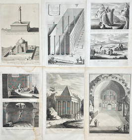
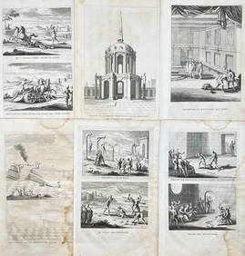
Antoine Augustin Calmet (1672-1757) - Set of 6 Religious Engravings - Tomb of Zechariah - Grotto ofProverde Auctions4.3(3)See Sold PriceFeb 28, 2024
Antoine Augustin Calmet (1672-1757) - Set of 6 Jewish Engravings - Tomb monument of the kings ofProverde Auctions4.3(3)See Sold PriceFeb 28, 2024
Antoine Augustin Calmet (1672-1757) - Set of 6 Architecture Engraving - Temple of Jerusalem -Proverde Auctions4.3(3)See Sold PriceFeb 28, 2024


![[BASEBALL]. [SHEET MUSIC]. KALBFLEISCH, J. H. The Live Oak ... (1 of 5)](https://p1.liveauctioneers.com/928/318880/171361400_1_x.jpg?height=282&quality=70&version=1707501302)