1952 ROBERT F. KENNEDY HANDWRITTEN LETTERJohn McInnis Auctioneers,LLC4.6(502)See Sold PriceFeb 25, 2024
CASED PRESENTATION HALF HULL MODEL OF THE BARQUE "HAWTHORNBANK" Last Quarter of the 19th CenturyEldred's4.7(409)See Sold PriceFeb 27, 2024
Lot Of 14 Jack Daniels And Country Club Glass Spirit BottlesRbfinearts4.4(571)See Sold PriceFeb 24, 2024
PR OF 17TH C. SPANISH BRASS CANDLESTICKSThomaston Place Auction Galleries4.4(386)See Sold PriceFeb 24, 2024
Lake Shore and Michigan Southern RR Special Excursions Timetable-July 7-13, 1892JM Hobby Supply and Railroad Artifact Auctions4.4(126)See Sold PriceFeb 24, 2024
Tiffany & Co. Sterling Silver Corkscrew Bottle OpenerSJ Auctioneers4.5(165)See Sold PriceMar 03, 2024
Rolls Royce Landau c1950s Gin/ Scotch TantalusPasadena Antique Auctions4.3(6)See Sold PriceMar 10, 2024
Sold1736 Engraving Plan and Fortifications of GibraltarBy the map maker and engraver Du Bosc. This map is from Rapin de Thoyras History of England. Copperplate engraving on fine hand laid paper. 15 x 24 sight, framed to 20.25 x 28.25. Two vertical folds,See Sold Price
Sold18th Century engraving - "Plan of the Town and18th Century engraving - "Plan of the Town and Fortifications of Gibraltar exactly on the spot in the year 1738", 13.5ins x 23ins, framed and glazedSee Sold Price
Sold1762 Magazine Gibraltar Folding PlanThe November 1762 issue of The London Magazine, 64 pages. Folding engraving being a plan of the town and fortifications at Gibraltar. Interesting content including war news and on witches and apparitiSee Sold Price
1762 Magazine Folding Plan of GibraltarThe November 1762 issue of The London Magazine, 64 pages. Folding engraving being a plan of the town and fortifications at Gibraltar. Interesting contnet including war news and on witches and apparitiSee Sold Price
1762 Magazine Folding Plan of GibraltarThe November 1762 issue of The London Magazine, 64 pages. Folding engraving being a plan of the town and fortifications at Gibraltar. Interesting content including war news and on witches and apparitiSee Sold Price
1762 Magazine Gibraltar Folding PlanThe November 1762 issue of The London Magazine, 64 pages. Folding engraving being a plan of the town and fortifications at Gibraltar. Interesting content including war news and on witches and apparitiSee Sold Price
SoldBasire (James) - Plan of The Town and Fortifications ofexactly taken on the spot in the year 1738, bird s eye view of the Gibraltar, with decorative key cartouche, and ships, engraving, 380 x 595mm., two vertical folds, Tindal, [c.1745].See Sold Price
SoldMap "Plan of the Town- Fortifications of Gibraltar[Map-fold out] From: Tindal's Continuation of Rapin's "History of England": "Plan of the Town & Fortifications of Gibraltar, exactly on the spot in the year 1738". English, 18th C. 15"h x 23 1/4"w= shSee Sold Price
SoldRare Period View of Gibraltar's Fortifications UnderRare Period View of Gibraltar's Fortifications Under AttackPlan of the Combined Attacks by Land and Sea to Take by Assault the Fortress of Gibraltar / Done by an Engineer in the French Army (London: SSee Sold Price
Plan of the town and fortifications of Gibraltar. DUTITLE/CONTENT OF MAP: 'Plan of the town and fortifications of Gibraltar shewing the new works made since the last siege for the better security of that fortress and the lines the Spaniards have builtSee Sold Price
Plan of the town and fortifications of Gibraltar. DUTITLE/CONTENT OF MAP: 'Plan of the town and fortifications of Gibraltar shewing the new works made since the last siege for the better security of that fortress and the lines the Spaniards have builtSee Sold Price
TWO (18th c) MARIINE PRINTS"Plan of the Town and Fortifications of Gibraltar, exactly taken on the Spot in the Year 1738" 17 x 24 inches. and "The Amsterdam by Petrus Schenk 1774, B. de Bakker. 22 x 26 inches.See Sold Price
SoldBasire (J.) Plan of GibralterBasire (James) Plan of The Town and Fortifications of Gibraltar, exactly taken on the spot in the year 1738, bird's eye view of the Gibraltar, with decorative key to the buildings, and ships,See Sold Price
Sold1 piece. Hand-Colored Engraved Map. Covens, Johan1 piece. Hand-Colored Engraved Map. Covens, Johannes; Mortier, Cornelis. Novaeau Plan de Gibraltar, avec ces Fortifications"; "Vue de la Ville de Gibraltar..."; "Nouvelle Carte d'une Partie, d'EspagneSee Sold Price
SoldJohn Baptist Homann Heirs, "Plan und Prospect von derJohn Baptist Homann Heirs, "Plan und Prospect von der stadt, Vestung, Bay und Fortifications von Gibraltar," 1733, H. - 20 in., W. - 23 in.See Sold Price
SoldPrints & Engravings.- Bellin. Plan de L'Isle de GoPrints & Engravings.- Bellin. Plan de L'Isle de Gorée,detailed map of the island of Gorée by Cape Vede on the west coast of Africa, depicting military encampments and fortifications, matted, iSee Sold Price
Historical map of Magdeburg,Historical map of Magdeburg, ''Magdeburgum Ducatus cognominis Metropolis ad Albium (...)'', old colored copperplate engraving by Matthäus Seutter, Augsburg, c. 1730, city plan with fortifications,See Sold Price
SoldCaribbean.- Dominica.- Sartine, comte d'Alby (AntoineCaribbean.- Dominica.- Sartine, comte d'Alby (Antoine de) Carte de la Dominique Prise par les François..., map of the island, with inset plan of key coastal fortifications, engraving with outlinSee Sold Price
Sebastian de Beaulieueleven loose 17th century engravings, 5 with military portraits above, all with town scenes, soldiers and fortification plans below, within decorative borders, circa 495 x 570mm (sheet)See Sold Price
SoldPlan Of Town & Fortifications Of Montreal, 1760Plan Of The Town & Fortifications Of Montreal London Magazine (1760), Engraving, 10 X 7.5 Inches.See Sold Price
Plan of the Fortifications of the City of Chester,Plan of the Fortifications of the City of Chester, from Joseph Hemingway's Book - History of the city of Chester from its foundation to the present time, 1831. Hand colored engraving. 16x20cm.See Sold Price
Sold1803 Map of Minorca and Plan of La ValetteTWO engravings: "A Map of the Island of Minorca" and "Plan of the Fortifications of La Valette and its Dependencies", printed for Cadell and Davies, London, 1803. Very Good, crop to one margin on eachSee Sold Price
Basire (James) - Plan of theTown and Fortifications ofbird s eye view of Gibraltar, with decorative key to the buildings, and ships, engraved map with original hand-colouring, 380 x 595mm., three vertical folds, some browning, Tindal, [c.1745] § CampiSee Sold Price
SoldArmaments, Fortifications and Battle PlansArmaments, Fortifications and Battle Plans,including several from Mr Tindal's Continuation, and a group from Diderot's Encyclopedie, amongst others, engravings and aquatints, one with originaSee Sold Price
MAP OF SALZBURG BY GEORGE BRAUN & FRANS HOGENBURG. 1588Thomaston Place Auction Galleries4.4(386)See Sold PriceFeb 24, 2024
DUNLEVIE c1856 Map Counties Of Gaspe & Bonaventure Quebec Canada SCARCE! #2Luis Porretta Fine Arts4.3(10)See Sold PriceMar 02, 2024
DEVINE c1856 Dr Salters Map Of Lake Huron Ontario Indian Lands etc. No. 7 ScarceLuis Porretta Fine Arts4.3(10)See Sold PriceMar 02, 2024
Ambroise TARDIEU c1822 Map Venice Napoleon Italian Campaign 17" x 11"Luis Porretta Fine Arts4.3(10)See Sold PriceMar 02, 2024
1822 Rare Map by Ambroise Tardieu Napoleon Caldiero Battle of Vento 17" x 11Luis Porretta Fine Arts4.3(10)See Sold PriceMar 02, 2024
1861 ARCHITECTURE 1ed Handbook to Cathedrals England 100+ Full Page EngravingsSchilb Antiquarian Rare Books4.8(421)See Sold PriceMar 31, 2024
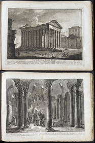
Morghen's Antichi Monumenti Esistenti - Volume with 44 EtchingsTrillium Antique Prints & Rare Books4.5(30)See Sold PriceFeb 24, 2024
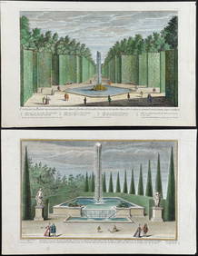
Demortain - 4 Fountain & Garden EngravingsTrillium Antique Prints & Rare Books4.5(30)See Sold PriceFeb 24, 2024
1738 BIBLE in DUTCH ILLUSTRATED w/ MAPS MASSIVE FOLIO in DUTCH antique BIBLIAJasper524.5(9.8k)See Sold PriceFeb 27, 2024
Birmingham.- Commercial map.- Smith (J. Pigott) To the Right Honourable William Earl of Dartmouth...Forum Auctions4.3(52)See Sold PriceFeb 29, 2024
1764 Bellin Map of Port Antonio, Jamaica -- Plan des Havres de Port Antonio et de Saint FrancoisJasper524.5(9.8k)See Sold PriceFeb 27, 2024
Two Hand-Colored 19th Century Maps of New Orleans and Louisiana, Larger- H.- 12 1/2 in., W.- 15 1/2Crescent City Auction Gallery4.3(229)See Sold PriceMar 08, 2024
1800s Jean Baptiste Pater A fete Champetre SIGNED FramedKCM Galleries4.7(164)See Sold PriceFeb 25, 2024
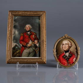
ANTIQUE PORTRAIT MINIATURES OF LORD HEATHFIELDPridham's Auctions & Appraisals4.7(223)See Sold PriceMar 02, 2024
Jean-Francois de Neufforge (1714 - 1791) - Set of 15 Architecture Prints - Plan de l' EdificeProverde Auctions4.3(3)See Sold PriceFeb 28, 2024