Sold14 maps of southern states. (1856), (1872).[United States: South]. 14 lithograph maps, hand-colored, very good condition, light toning in margins. ++ 7 maps from one or more editions of ''Asher & Adams' New Statistical And Topographical Atlas.See Sold Price
Sold1862, 1872 Maps - VA, Southern States1862 Johnson map of Richmond, VA (18 x 27"). 1872 Warner & Beers map of Southern States (29 x 18).See Sold Price
Sold14 maps of Midwestern states [1857], (1872).[United States: Midwest]. 14 lithograph maps, hand-colored, largely very good condition, some toning in margins ++6 maps issued by DeSilver, c.1857. Each approx. 12 1/4 x 15 1/4 inches. Includes: YounSee Sold Price
1872 Map of Southern StatesAuthor: Gamble Title: 1872 Map of Southern States Medium: Ink on Paper Dimensions: 15"X23" Description: Map dated 1872 engraved by W.H. Gamble. It captures the Southern states of Arkansas, MississippiSee Sold Price
1872 Map of Southern StatesAuthor: Gamble Title: 1872 Map of Southern States Medium: Ink on Paper Dimensions: 15"X23" Map dated 1872 engraved by W.H. Gamble. It captures the Southern states of Arkansas, Mississippi and LouisianSee Sold Price
1872 Map of the Southern StatesAuthor: Gamble Title: 1872 Map of the Southern States Medium: Ink on Paper Dimensions: 15"X23" Map dated 1872 engraved by W.H. Gamble. It captures the Southern states of Arkansas, Mississippi and LouiSee Sold Price
SoldThree Colored Maps of Southern StatesThree Colored Maps of Southern States: Virginia & West Virginia, Kentucky and Tennessee, 14 1/2" x 21" Removed from Atlas, Good Condition.See Sold Price
SoldMoll: Antique Map of West Indies Central America, 1746Title/Content of Map: Southern United States, West Indes Mexico Central America Date Printed: 1746 Cartographer: Thomas Salmon & Herman Moll Material/Medium: Paper Size: 14 1/2" 9 1/2" Copperplate engSee Sold Price
Sold2 Colton Pocket Maps, State of New York 1856 and2 Colton Pocket Maps, State of New York 1856 and Township Map of New York 1872-- Dimensions: ---See Sold Price
1872 Warner Beers Map Western Portion of SouthernTitle/Content of Map: 1872 Warner Beers Map Western Portion of Southern States -- County Map of Tennessee, Kentucky, Alabama. Mississippi, Arkansas and Louisiana Date: 1872, Chicago Cartographer: WarnSee Sold Price
Sold1872 Warner Beers Map Western Portion of SouthernReserve Reduced! Title/Content of Map: 1872 Warner Beers Map Western Portion of Southern States -- County Map of Tennessee, Kentucky, Alabama. Mississippi, Arkansas and Louisiana Date: 1872, Chicago CSee Sold Price
1872 Warner Beers Map Western Portion of SouthernTitle/Content of Map: 1872 Warner Beers Map Western Portion of Southern States -- County Map of Tennessee, Kentucky, Alabama. Mississippi, Arkansas and Louisiana Date: 1872, Chicago Cartographer: WarnSee Sold Price
1872 Warner Beers Map Western Portion of SouthernTitle/Content of Map: 1872 Warner Beers Map Western Portion of Southern States -- County Map of Tennessee, Kentucky, Alabama. Mississippi, Arkansas and Louisiana Date Printed: 1872, Chicago CartographSee Sold Price
SoldMidwest US Maps (8) (63200)8 maps featuring the Midwestern states. 1) Ohio by Counties with Railroads. Published by Geo. F. Cram, Chicago, IL. 1883. Approximately 14.5" x 21.5." 2) A New Map of the State of Ohio. 1856. PublisheSee Sold Price
Midwest US Maps (8) (63200)8 maps featuring the Midwestern states. 1) Ohio by Counties with Railroads. Published by Geo. F. Cram, Chicago, IL. 1883. Approximately 14.5" x 21.5." 2) A New Map of the State of Ohio. 1856. PublisheSee Sold Price
1872 Map of Arkansas, Mississippi and LouisianaAuthor: Gamble Title: 1872 Map of Arkansas, Mississippi and Louisiana Medium: Ink on Paper Dimensions: 15"X23" Map dated 1872 engraved by W.H. Gamble. It captures the Southern states of Arkansas, MissSee Sold Price
1872 Map of Arkansas, Louisiana and MississippiTitle: 1872 Map of Arkansas, Louisiana and Mississippi Medium: Ink on Paper Dimensions: 15"X23" Description: Map dated 1872 engraved by W.H. Gamble. It captures the Southern states of Arkansas, MissisSee Sold Price
Sold1872 Louisiana, Mississippi, Arkansas MapAuthor: Gamble Title: 1872 Louisiana, Mississippi, Arkansas Map Medium: Ink on Paper Dimensions: 15"X23" Map dated 1872 engraved by W.H. Gamble. It captures the Southern states of Arkansas, MississippSee Sold Price
SoldMap of "The Seat of War" in the Southern StatesMap of "The Seat of War" in the Southern part of Virginia, North Carolina & Northern Part of South Carolina by Thomas. Kitchin Sen., London 1781 - 12" X 14"See Sold Price
SoldA New Map of the State of Pennsylvania. Phila: Chas.A New Map of the State of Pennsylvania. Phila: Chas. Desilver, 1856. 14.5 x 17.5". hand-colored. Separated at some folds, light browning. Front cover detached.See Sold Price
SoldLOT OF 8 UNITED STATES MAPSLOT OF 8 UNITED STATES MAPS. 1. 1894-N.EAST TEXAS, N.W. LOUISIANNA. 2. 1895-KANSAS, INDANA TERRITORY, MO.AR. 3. 1856-ST. MARKS RIVER FLORIDA. 4. 1882-COUNTY MAP OF FLORIDA. 5. 1872-MAP OF MIDDLE STATESee Sold Price
St. Louis, Iron Mountain and Southern Railway.Title: St. Louis, Iron Mountain and Southern Railway. Publication Date: 1878 Cartographer: Publisher: SL, IM & S. Ry Size: 10.25Height - 14.25Width Map of the United States showing the St. Louis, IronSee Sold Price
SoldMAP OF NEW ORLEANSdepicting a section of the Southern United States and the Mississippi River Condition: with some discoloration and creasing 14 x 18 1/2 inches sight; 23 1/4 x 28 inches framedSee Sold Price
Sold(4) 1838 Bradford Maps: NY, PA, NYC, Phila.[United States/NY/PA/Phila] 4 Maps. ++ NEW YORK State. ++ NEW YORK City. [Street grid of central & southern Manhattan and northwestern Brooklyn.] ++ PENNSYLVANIA. ++ PHILADELPHIA. ++ Maps 14, 15, 17,See Sold Price
MAP - Dufour, A. H. ( Malte / Brun ) :MAP - ESPAGNE PARTIE SUD DIVISEE EN PROVINCES ANCIENNES ( MAPLuis Porretta Fine Arts4.3(10)See Sold PriceMar 02, 2024
1950 Menaboni Print, Mocking Bird ( Black/White )Connoisseur Auctions4(333)See Sold PriceFeb 24, 2024
1950 Menaboni Bird Print - Red-wing Blackbird, by Athos MenaboniConnoisseur Auctions4(333)See Sold PriceFeb 24, 2024
1887 Appletons' General Guide to the United State and Canada Part IIRail & Road Auctions4.6(165)See Sold PriceMar 08, 2024
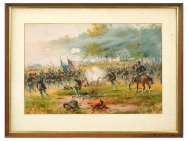
ANTIQUE AMERICAN CIVIL WAR LITHO BY THURE DE THULSTRUPAntique Arena Inc.4.5(852)See Sold PriceFeb 24, 2024
Putnam - First Map of the State of Ohio by Rufus PutnamTrillium Antique Prints & Rare Books4.5(30)See Sold PriceFeb 24, 2024
Northern & Southern Africa. Maghreb. Orange River Sovereignty. HALL 1856 mapJasper524.5(9.8k)See Sold PriceFeb 28, 2024
SOUTHERN AFRICA Monomotapa (Mutapa Kingdom) Cafrerie (Kaffraria) MALLET 1683 mapJasper524.5(9.8k)See Sold PriceFeb 28, 2024


![14 maps of Midwestern states [1857], (1872). (1 of 10)](https://p1.liveauctioneers.com/179/17501/5894403_1_x.jpg?height=282&quality=70&version=1225486369)