Sold1848 Houze ATLAS Geography 101 MAPS Europe Africa1848 Houze ATLAS Geography 101 MAPS Europe Africa America Hand-Colored England A rare 19th-century atlas filled with over 100 full-page maps hand-traced in color. These maps by Antoine Philippe HouzeSee Sold Price
Sold101 MapsVarious Ages, Conozca Sus Raices, 20th Century Map of the Indigenous Peoples of Mexico and Centro America,1995, 24" x 19", folds; 35 Topographical Map of the Mineral Districts of California, 1853, copSee Sold Price
Sold~101 maps (~97 color): Latin America, 1783-[c1915[Latin America]. About 100 maps (few duplicates). Includes about 44 maps of countries in South America, 27 of Carribean islands (largely Puerto Rico and Cuba), and 30 maps of Mexico and/or Central AmeSee Sold Price
SoldColton's General AtlasColton (J.H., publisher) Colton's General Atlas, 101 maps, city plans, and plates, including 6 double-page, all but 5 with original hand-colouring, each within a decorative border (uncolouredSee Sold Price
Houzé (A) Atlas UniverselHouzé (A.) Atlas Universel Historique et Géographique, 101 maps and 101 plates of biblical and historical scenes and portraits, from classical antiquity to napoleonic times, engraved maps withSee Sold Price
SoldREES. Map of the Counties of Cook and Dupage101. [MAP]. REES, James H. (land agent). Map of the Counties of Cook and Dupage the East Part of Kane and Kendall the North Part of Will, State of Illinois, Compiled by James H. Rees, LandSee Sold Price
Danica Phelps (American, b. 1971)Four works of art: Sex #14 (spill), Sex #62 (meal), Sex #101 (map), and Sex #139 (people), 2003; Mixed media on boards; Each signed and dated 9 1/4" x 9" (largest), 5 7/8" x 5 1/8" (smallest); ProvenaSee Sold Price
SoldHitchcock, Texas. Manuscript Map101. [MAP]. [HITCHCOCK, TEXAS]. Untitled manuscript map on heavy paper mounted on original linen, black and red ink with grey wash, showing Gulf, Colorado & Santa Fe Railway, Depot Grounds, in HitSee Sold Price
SoldJohnson’s New Illustrated Family Atlas. 1865.[Atlas] Johnson’s New Illustrated (Steel Plate) Family Atlas... NY: Johnson and Ward, 1865. 104 maps/illustrations, with 103-104 being insets on map 101-102. Maps are hand colored, and include stateSee Sold Price
SoldDas Afrika LexikonDas Afrika Lexikon Ein Kontinent in 1000 Stichwörter Mabe, Jacob E. Stuttgart: J.B. Metzler (2001) ISBN: 3-476-01538-6 German text 720 pages 101 illustrations, maps Hardcover without dust jacket 24 cSee Sold Price
Sold21 PCS, U.S. MILITARY ISSUE COLD WAR SURVIVAL MAPSU.S. Government, 1950. Collection of twenty-one armed services CL 100 and 101 survival maps of the Gulf of Bothnia and the White Sea, printed on fabric. Approx. 39" x 42" (each) Item from the Estate oSee Sold Price
Scarce mining map of Gilpin Co. ColoradoHeading: (Colorado) Author: Title: Mining Map of Northern Gilpin County Colorado Place Published: Denver Publisher:Clason Map Co. Date Published: 1916 Description: Blue-line mapSee Sold Price
SoldScarce mining map of Gilpin Co. ColoradoHeading: (Colorado) Author: Title: Mining Map of Northern Gilpin County Colorado Place Published: Denver Publisher:Clason Map Co. Date Published: 1916 Description: Blue-linSee Sold Price
Scarce mining map of Gilpin Co. ColoradoHeading: (Colorado) Author: Title: Mining Map of Northern Gilpin County Colorado Place Published: Denver Publisher:Clason Map Co. Date Published: 1916 Description: Blue-linSee Sold Price
SoldHand-colored map of Daimyo Doman, JapanTitle: Hand-colored manuscript map of Daimyo Doman, Japan Author: ** Description: Hand-colored manuscript folding map 101.5x72 cm. (40x28¼"), boards attached.19th-century map of the Boso Peninsula wiSee Sold Price
SoldHALL, Charles Francis.Life With The Esquimaux. 2 Vols. 8vo. 1 large folding engraved map & 101 plates & text illus. (incl. 2 charts). contemporary half calf (worn, spines defective, boards off, internally very good). LondoSee Sold Price
SoldAmerican Map Co. world map No. 101American Map Co. world map No. 101, 20th c., "Mid-Century Map of the World", 39.5"h x 62.5"w (sight), 43.5"h x 66.5"w (with frame) Provenance: Ford Foundation Collection, NYSee Sold Price
SoldHouzé (A.) Atlas Universel HistoriqueHouzé (A.) Atlas Universel Historique101 maps and 101 plates of biblical and historical scenes and portraits, from classical antiquity to napoleonic times, engraved maps with original hand-colSee Sold Price
SoldOgilby & Senex The Roads through EnglandOgilby (John and John Senex) The Roads through England or, Ogilby's Survey Revised, Improved, and Reduced,engraved title, general map, and 101 strip road maps, title in French and English, damSee Sold Price
BOOK, References, ShirleyReferences. Rodney W. Shirley, [Lot of 5] Map Collectors' Circle - Nos. 90, 94, 95, 97, and 101: Early Printed Maps of the British Isles 1477-1650 Parts-I-V, 1973-74 (published). Black & White. Map CoSee Sold Price
SoldWitsen (Nicolaas) Noord en Oost TartaryenWitsen (Nicolaas) Noord en Oost Tartaryen,2 vol., 2 engraved additional pictorial titles, engraved dedication to Peter Alexeevich , portrait of the author and 99 (of 101) plates and maps, someSee Sold Price
Senex (John) - The Roads through England delineated or,Revised, Improved and Reduced to a size Portable for the Pocket , engraved general map of England and 101 strip road maps, printed back to back, some faint offsetting, last few sheets browned, last twSee Sold Price
SoldWILLIAM BUTLER "WILD NORTHLAND" Ltd edition 1903New York. New Amsterdam Book Company. 1903. 1/2 cloth bound. 101/210. pull out map 9 1/2 x 6 1/2 inchesSee Sold Price
SoldHarrison (Walter)Harrison (Walter) A New and Universal History, Description and Survey...of London and Westminster, 101 engraved plates and maps, a few folding, lacking frontispiece, U2 and 7B2, title laid dowSee Sold Price
Central Anatolia Cihanbeyli Yastik Rug 3 ft 4 in x 1 ft 9 in (1.01 m x 0.53 m)Nazmiyal Auctions4.4(34)See Sold PriceFeb 25, 2024
Central Anatolia Karapinar Rug (mounted) 3 ft 11 in x 3 ft 4 in (1.19 m x 1.01 m)Nazmiyal Auctions4.4(34)See Sold PriceFeb 25, 2024
1885 CIVIL WAR 1ed Famous Memoirs US Grant Sheridan Sherman 6v RARE LOT MapsSchilb Antiquarian Rare Books4.8(428)See Sold PriceMar 10, 2024
No Reserve Antique Caucasian Kuba Runner Rug 14 ft 8 in x 3 ft 4 in (4.47 m x 1.01 m)Nazmiyal Auctions4.4(34)See Sold PriceFeb 25, 2024
Large lot of assorted prints. 18th-20th century. To include: North American and other maps, CivilTremont Auctions4.5(297)See Sold PriceFeb 25, 2024
Large Assortment of Railroad Items - Insulators, Globes, Hand Bell, Posters, Maps, Timetables,Rail & Road Auctions4.6(165)See Sold PriceMar 07, 2024
Collection of Allied Military Silk Printed Maps, WWII Era and LaterMaterial Culture4.6(778)See Sold PriceFeb 29, 2024
Rand McNally Railroad Map Cabinet w/ 21 Railroad MapsRail & Road Auctions4.6(165)See Sold PriceMar 08, 2024
(2) CHINESE CARVED HARDWOOD ARCHITECTURAL DOOR PANELS, 101" X 30"Austin Auction Gallery4.7(1.2k)See Sold PriceFeb 25, 2024
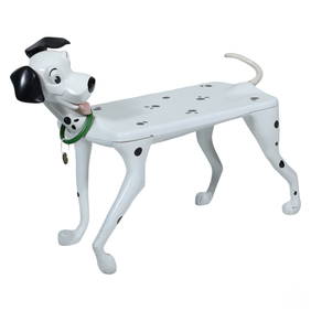
Starform Disney 101 Dalmatians Accent Table BenchHill Auction Gallery 4.7(1k)See Sold PriceFeb 28, 2024
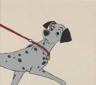
An Original Production Cel from "101 Dalmatians."Van Eaton Galleries4.6(99)See Sold PriceMar 02, 2024
Willem Blaeu, Etc. 17th C. Antiquarian Maps, 2Auctions at Showplace4.6(740)See Sold PriceMar 17, 2024
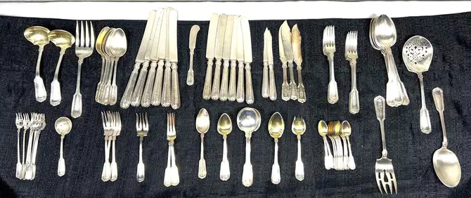
GORHAM STERLING SILVER FLATWARE SERVICE 101 piece with monogramsBasel Auction House4.5(47)See Sold PriceFeb 24, 2024
Putnam - First Map of the State of Ohio by Rufus PutnamTrillium Antique Prints & Rare Books4.5(32)See Sold PriceFeb 24, 2024
De Jode, Rare, pub. 1593 - Map of Africa (Africae Vera Forma, et Situs)Trillium Antique Prints & Rare Books4.5(32)See Sold PriceFeb 24, 2024
Platinum Ring with 1.01 Carat Princess-Cut DiamondDirect Auction Galleries 4.7(337)See Sold PriceFeb 24, 2024
Lionel Prewar 101 Bridge with 104 Center Span and 100 Approach X2 - 106 Bridge with 110 Center SpanHarris Toy & Train Auctions4.4(130)See Sold PriceMar 01, 2024