2012 Famous Fabrics President John F. Kennedy & Marilyn Monroe Signed Cut 1/1Mynt Auctions4.6(697)See Sold PriceFeb 26, 2024
1952 JOHN F. KENNEDY LETTER to MS. HELEN KEYESJohn McInnis Auctioneers,LLC4.5(505)See Sold PriceFeb 25, 2024
Group of FDR and Truman Political Campaign and Satire ButtonsDana J. Tharp Auctions4.7(271)See Sold PriceFeb 24, 2024
Large Collection of Antique Buttons DisplayPremier Auction Galleries4.4(331)See Sold PriceMar 09, 2024
NASA Apollo Blueprints – Charles Bell Collection (100+ Blueprints)Cardenas Auctions4.2(6)See Sold PriceMar 05, 2025
RINGLING BROTHERS CIRCUS ELEPHANT HEADDRESS PORCELAIN SIGN.Dan Morphy Auctions4.2(1.3k)See Sold PriceFeb 24, 2024
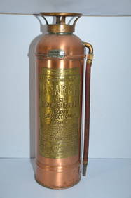
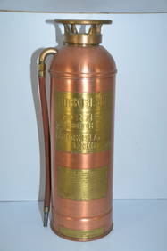
Denver and Rio Grande Western RR Large Copper and Brass Fire ExtinguisherJM Hobby Supply and Railroad Artifact Auctions4.4(127)See Sold PriceFeb 24, 2024
"THE PRESIDENTS OF THE UNITED STATES" N. CURRIERJohn McInnis Auctioneers,LLC4.5(505)See Sold PriceFeb 25, 2024
THE JOHN F. KENNEDY MEMORIAL at RUNNYMEDEJohn McInnis Auctioneers,LLC4.5(505)See Sold PriceFeb 25, 2024
Hubert Hilscher CYRK Tiger Cat Polish Circus 1971 PosterBasel Auction House4.5(47)See Sold PriceFeb 24, 2024
JOHN F. KENNEDY, Jr. & AUCHINCLOSS GRANDCHILDRENJohn McInnis Auctioneers,LLC4.5(505)See Sold PriceFeb 25, 2024
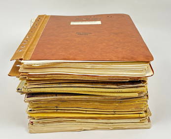
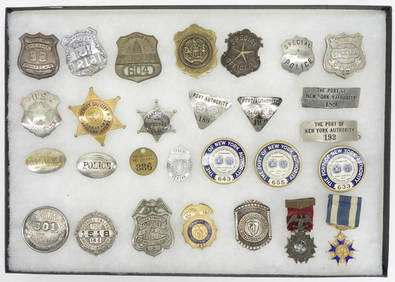
28PC Collection of New York City Police BadgesBruneau & Co. Auctioneers4.5(491)See Sold PriceMar 18, 2024
Rock Island RR Large Copper and Brass Fire ExtinguisherJM Hobby Supply and Railroad Artifact Auctions4.4(127)See Sold PriceFeb 24, 2024
Sold10 Atlas Colored Maps by Mitchell (69053)1839 Mitchell's colored maps of the world. Approx 10.5" x 9.5". Single truck-Africa. 2x Asia. 2x France, Spain, Portugal and Italy. Germany, Switzerland and Northern Italy. 2x Great Britain and IrelanSee Sold Price
Sold1872 MITCHELL COUNTY MAP OF KENTUCKY AND TENNESSEEHand colored map by Samuel Augustus Mitchell measuring 13 by 10 inches. It is in very good condition with some minor foxing to border.See Sold Price
Sold[2] Hand colored engraved maps, Louisiana, by S.[2] Hand colored engraved maps, Louisiana, by S. Augustus Mitchell, Philadelphia, 1847. Foxing. Sight size: 10 ¾ x 13 ½Â”; Alabama, Mississippi, Lousiana & Arkansas, by J.H. Young, 18See Sold Price
SoldMitchell: European Russia & ScandinaviaPlace/Date: Philadelphia / 1870 Size: 13 1/2" x 10 3/4" Condition: full color; light overall age toning The beautifully detailed and colored map of Scandinavia and European Russia (encompassing presenSee Sold Price
Mitchell: Canadian Maritime ProvincesCartographer: S. A. Mitchell Place & Date: Philadelphia / 1870 Size: 10 5/8" x 13 3/8" Condition: full color; light overall age toning The beautifully detailed and colored map of the Canadian MaritimeSee Sold Price
Mitchell: Chile / Brazil, Bolivia, Paraguay & UruguayCartographer: S. A. Mitchell Place/Date: Philadelphia / 1870 Size: 13 3/8" x 10 3/4" Condition: full color; light overall age toning Two beautifully detailed and colored maps of South American regionsSee Sold Price
Mitchell: Chile / Brazil, Bolivia, Paraguay & UruguayCartographer: S. A. Mitchell Place/Date: Philadelphia / 1870 Size: 13 3/8" x 10 3/4" Condition: full color; light overall age toning Two beautifully detailed and colored maps of South American regionsSee Sold Price
Mitchell: Colombia, Venezuela; Peru, Ecuador; ArgentinaCartographer: S. A. Mitchell Place/Date: Philadelphia / 1870 Size: 10 5/8" x 13 3/8" Condition: full color; light overall age toning Three beautifully detailed and colored maps of South American regioSee Sold Price
S.A. Mitchell: Map of Africa, 1867Map: Map of Africa, showing its most Recent Discoveries. Cartographer: S. A. Mitchell Place & Date: Philadelphia / 1867/1870 Size: 13 1/8" x 10 3/4" A beautifully colored exemplar of the African contiSee Sold Price
SoldMitchell: County Map of Quebec/Montreal InsetCartographer: S. A. Mitchell Place/Date: Philadelphia / 1870 Size: 13 1/4" x 10 3/4" Condition: full color; light overall age toning The beautifully detailed and colored county map of Quebec from theSee Sold Price
Mitchell: Antique Map of Asia, 1849Map: 1849 Mitchell Map of Asia - Map of Asia Cartographer: S. A. Mitchell Year / Place: 1849 Philadelphia Dimensions: 8.2 x 10.5 in. Condition: Very good condition. Nicely colored. Margins have age toSee Sold Price
SoldMitchell: County Map of Texas, 1862County Map of Texas, S. Augustus Mitchell, 1862. 10.75 x 13.375 inches. Steel engraved map, with hand colored wash and outlines. Inset map of Galveston Bay, and Vicinity. Colored by county and territoSee Sold Price
Mitchell: Antique Map of New Orleans, 1867Map: 1867 Mithell Map of New Orleans -- Plan of New Orleans Cartographer: S Mitchell Year / Place: 1867, Philadelphia Map Dimensions: 9.2 x 10.9 in. Condition: Very Good. Nice impression, hand coloredSee Sold Price
Mitchell: Antique County Map of Florida, 1870Map: County Map of Florida Cartographer: S. A. Mitchell Place & Date: Philadelphia / 1870 Size: 13 1/4" x 10 3/4" Condition: full color; light overall age toning The beautifully detailed and colored cSee Sold Price
Mitchell: No. 5 Map of the United States, 1852No. 5 Map of the United States, Mitchell 1852. 10.625 x 16.75 inches. Hand-colored in pastel tones. From 1854 Cowperthwait, Desilver and Butler school geography. Double-page map contains transitionalSee Sold Price
SoldMitchell: Antique County Map of Texas, 1870Map: County Map of Texas Cartographer: S. A. Mitchell Place & Date: Philadelphia / 1870 Size: 13 1/4" x 10 3/4" Condition: full color; light overall age toning The beautifully detailed and colored couSee Sold Price
Mitchell: Antique County Map of Quebec/Montreal, 1870Map: Map of Quebec in Counties Cartographer: S. A. Mitchell Place & Date: Philadelphia / 1870 Size: 13 1/4" x 10 3/4" Condition: full color; light overall age toning The beautifully detailed and colorSee Sold Price
County Map of Arizona and New MexicoPublication Date: 1867 Title: County Map of Arizona and New Mexico Cartographer: MITCHELL, S.A. Publisher: MITCHELL, S.A. Colored by county (5 in AZ; 10 in NM). Tucson capital of AZ, no Phoenix. "Pt.See Sold Price
County Map of Arizona and New MexicoPublication Date: 1867 Title: County Map of Arizona and New Mexico Cartographer: MITCHELL, S.A. Publisher: MITCHELL, S.A. Height: 11.2 Width: 14.3 Colored by county (5 in AZ; 10 in NM). Tucson capitalSee Sold Price
SoldMitchell: Plan of St. LouisMap: St. Louis Cartographer: S. A. Mitchell Place & Date: Philadelphia / 1870 Size: 10 7/8" x 13 7/8" Condition: full color; light overall age toning The beautifully detailed and colored street plan oSee Sold Price
SoldCounty Map of the State of IllinoisReserve Reduced! Title: County Map of the State of Illinois Publication Date: 1867 Cartographer: S. Augustus Mitchell, Jr. Publisher: S. Augustus Mitchell Size: 12.8 X 10 Colored by county (or wards wSee Sold Price
Mitchell: Plan of St. LouisCartographer: S. A. Mitchell Place/Date: Philadelphia / 1870 Size: 10 7/8" x 13 7/8" Condition: full color; light overall age toning The beautifully detailed and colored street plan of St. Louis fromSee Sold Price
Mitchell: Antique Plan of St. Louis, 1870Map: St. Louis Cartographer: S. A. Mitchell Place & Date: Philadelphia / 1870 Size: 10 7/8" x 13 7/8" Condition: full color; light overall age toning The beautifully detailed and colored street plan oSee Sold Price
SoldMap, plan of Boston, 1867, by S. AugustusMitchell, hand colored engraving. Sight size 12" x 10", overall in a modern burl walnut frame new mount with UV glass 17 1/2" x 15 1/2". Very good condition.See Sold Price
PIETER SCHENK / VALK / JANSSEN Hand Colored Map of Rhodes Greece ca1702 vgcLuis Porretta Fine Arts4.3(10)See Sold PriceMar 02, 2024
1849 Mitchell School ATLAS 24 MAPS America Holy Land France Africa Egypt AsiaSchilb Antiquarian Rare Books4.8(428)See Sold PriceMar 31, 2024
HAMMOND'S READY REFERENCE HISTORICAL ATLAS 1920North American Artifact Auctions4.7(198)See Sold PriceApr 20, 2024
Mitchell - Map of the City of Washington (Washington, DC)Trillium Antique Prints & Rare Books4.5(32)See Sold PriceFeb 24, 2024
COLONIAL AFRICA Afrique. League of Nations Mandates. Ethnicity 1938 old mapJasper524.5(9.9k)See Sold PriceFeb 28, 2024
COLONIAL TOGO & BENIN (Dahomey). Porto Novo & Lomé city ville plans 1929 mapJasper524.5(9.9k)See Sold PriceFeb 28, 2024
FRENCH WEST AFRICA. Senegal & Mauritanie/Mauritania. Dakar plan 1931 old mapJasper524.5(9.9k)See Sold PriceFeb 28, 2024
COLONIAL GABON & CONGO. Afrique équatoriale française. Brazzaville plan 1929 mapJasper524.5(9.9k)See Sold PriceFeb 28, 2024
FRENCH SUDAN (Now Mali). Soudan Français. Bamako city plan de la ville 1929 mapJasper524.5(9.9k)See Sold PriceFeb 28, 2024
COLONIAL AFRICA Afrique. League of Nations Mandates. Ethnicity 1929 old mapJasper524.5(9.9k)See Sold PriceFeb 28, 2024
COLONIAL AFRICA Afrique. League of Nations Mandates. Ethnicity 1931 old mapJasper524.5(9.9k)See Sold PriceFeb 28, 2024
FRENCH COLONIAL GUINEA. Guinee Française. Conakry city town ville plan 1931 mapJasper524.5(9.9k)See Sold PriceFeb 28, 2024
FRENCH WEST AFRICA. Senegal & Mauritanie/Mauritania. Dakar plan 1929 old mapJasper524.5(9.9k)See Sold PriceFeb 28, 2024
Colonial West Africa. Nigeria Cameroon Congo. British German. TIMES 1900 mapJasper524.5(9.9k)See Sold PriceFeb 28, 2024
FRENCH SUDAN (Now Mali). Soudan Français. Bamako city plan de la ville 1931 mapJasper524.5(9.9k)See Sold PriceFeb 28, 2024
COLONIAL TOGO & BENIN (Dahomey). Porto Novo & Lomé city ville plans 1931 mapJasper524.5(9.9k)See Sold PriceFeb 28, 2024
COLONIAL TOGO & BENIN (Dahomey). Porto Novo & Lomé city ville plans 1938 mapJasper524.5(9.9k)See Sold PriceFeb 28, 2024
COLONIAL GABON & CONGO. Afrique équatoriale française. Brazzaville plan 1938 mapJasper524.5(9.9k)See Sold PriceFeb 28, 2024
FRENCH WEST AFRICA. Senegal & Mauritanie/Mauritania. Dakar plan 1938 old mapJasper524.5(9.9k)See Sold PriceFeb 28, 2024


![[2] Hand colored engraved maps, Louisiana, by S. (1 of 9)](https://p1.liveauctioneers.com/4503/154077/77880003_1_x.jpg?height=282&quality=70&version=1573177471)


