Sold-. Seale (Richard William) - Map of the County offrom North Mimms to Thames Ditton, and from Langley to Leytonstone, the map flanked by panels of the arms of all the Free Companies of London, decorative armorial title cartouche, lower right, large aSee Sold Price
SoldSeale (Richard William) Map of the County of MiddlSeale (Richard William) Map of the County of Middlesex,from North Mimms to Thames Ditton, and from Langley to Leytonstone, the map flanked by panels of the arms of all the Free Companies of LoSee Sold Price
Seale (Richard William) MiddlesexSeale (Richard William) Map of the County of Middlesex,flanked by panels of the arms of all the Free Companies of London, decorative armorial title cartouche, lower right, engraved map with orSee Sold Price
SoldSeale (R.W.) Map of the County of MiddlesexSeale (Richard William) Map of the County of Middlesex,from North Mimms to Thames Ditton, and from Langley to Leytonstone, the map flanked by panels of the arms of all the Free Companies of LoSee Sold Price
SoldSeale (R. W.) County of MiddlesexSeale (Richard William) Map of the County of Middlesex,from North Mimms to Thames Ditton, and from Langley to Leytonstone, the map flanked by panels of the arms of all the Free Companies of LoSee Sold Price
British County MapsBritish County Maps.- Seale (Richard William) Map of the County of Middlesex, folding engraved map, outlined in colour, decorative cartouche, side borders of coats-of-arms of the City Companies, disseSee Sold Price
SoldSeale (R.) Map of the County of MiddlesexSeale (Richard William) To the Most Noble Thomas Holles Pelham, Duke of Newcastle...this Map of the County of Middlesex is dedicated,from North Mimms to Thames Ditton, and from Langley to LeytSee Sold Price
Sold[MAPS & ATLASES]. SEALE, Richard William. A Map of[MAPS & ATLASES]. SEALE, Richard William. A Map of North America With the European Settlements & whatever else is remarkable in ye West Indies from the latest and best Observations. [London, 1733 or lSee Sold Price
Sold* SEALE, Richard William. A Map of North America With* SEALE, Richard William. A Map of North America With the European Settlements & whatever else is remarkable in ye West Indies from the latest and best Observations. [London, 1745]. Engraved map, imagSee Sold Price
SoldSEALE, RICHARD WILLIAM. A Map of North AmericaSEALE, RICHARD WILLIAM. A Map of North America. Double-page engraved map, 375x470 mm, trimmed close along right margin but outside of neat line, other margins ample; minor browning. London, 1745 WithSee Sold Price
Sold[Map] Seale, Richard. Map of North AmericaSeale, Richard William. A Map of North America with the European Settlements & Whatever Else is Remarkable in ye West Indies.... [London, c.1745.] Sheet measuring 505mm x 408mm. Rather toned, 2" closeSee Sold Price
SoldD'Anville/Seale. A Map of North America. 1766.[America] D’Anville, Jean Baptiste Bourguignon. Seale, Richard William. “A Map of North America; Published under the Patronage of the Duke of Orleans by D'Anville.” London, 1766. EnSee Sold Price
SoldMiddle East.- Seale (Richard William) Arabia, [1764].Middle East.- Seale (Richard William) Arabia, fine map centered on Arabia, showing Jirja and Alexandria in Egypt, and to the east are Iraq and part of Persia, with Baghdad, Basra and Shiraz, Cabara anSee Sold Price
SoldSeale (R. W.) Map of Principality of MaltaSeale (Richard William) A New Map & Land Chart of the Sovereign Principality of Malta,Malta and Gozo with large pictorial title cartouche depicting a knight of Malta reaching for a sinking shiSee Sold Price
SoldMap, William Richard SealeRichard William Seale (British,1703-1762), "A Map of the Kingdoms of Spain and Portugal from the latest and best Observations," circa 1730, hand-colored engraving, sight (image): 15"h x 18"w, overallSee Sold Price
SoldSeale (R. W.) Islands of Malta and Goza-. Seale (Richard William) engraver An Accurate Map of the Islands of Malta and Goza; An exact Plan of the Capital City and Port of Malta, together 2 engraved maps of Malta and Valetta, with hSee Sold Price
SoldSEALE, RICHARD WILLIAM. A New and Accurate MapSEALE, RICHARD WILLIAM. A New and Accurate Map of North America . . . Also the New Divisions according to the late Treaty of Peace. Double-page engraved map, 495x535 mm, wide margins; hand-colored inSee Sold Price
ItalyRichard William Seale - Giacomo Cantelli da Vignola. Due carte dell'Italia. Richard William Seale, A Map of Italy with its Kingdoms, States... [1745]. Incisione in rame con coloritura coeva. mm 385x4See Sold Price
SoldRICHARD WILLIAM SEALE HAND COLORED MAP 8" X 12"RICHARD WILLIAM SEALE (BRITISH FL. 1732-1775), HAND COLORED MAP, 8" X 12", "GALLIA CISALPINA":Tab. XV; modern custom frame. Seale was an 18th century engraver and cartographer from London. Date of priSee Sold Price
FORTIFICATIONS & MILITARY ARCHITECTURE[Fortifications and Military Architecture] Collection of six maps sold together [Seale, Richard William] PLAN OF THE CITY OF DOWAY; AETH A STRONG FRONTIER TOWN IN BRABANT; PLAN OF THE BATTLE OF MALPLASee Sold Price
[MILITARY ARCHITECTURE] Six plans by Seale[Fortifications and Military Architecture] Collection of six maps sold together SEALE, Richard William. PLAN OF THE CITY OF DOWAY; AETH A STRONG FRONTIER TOWN IN BRABANT; PLAN OF THE BATTLE OF MALPLAQSee Sold Price
SoldRichard William Seale (1732-1775, London), "A map ofRichard William Seale (1732-1775, London), "A map of North America with the European Settlements...West Indies," c. 1745, H. - 15 7/8 in., W. - 120 3/8 in.See Sold Price
SoldRichard William Seale (1732-1775), "Foldable 3 Map SetRichard William Seale (1732-1775), "Foldable 3 Map Set of England, Ireland, and Scotland," 1750, paper on linen, Each.- H.- W. - 46 in. (3 Pcs.)See Sold Price
SoldRichard William Seale (1732-1775, London), "A Map ofRichard William Seale (1732-1775, London), "A Map of South America with all European Settlements," c. 1740, H. - 20 1/2 in., W. - 15 7/8 in.See Sold Price
Map UNITED COUNTIES LEEDS & GRENVILLE by Walling 1861 Rare Canada Map 5ft x 5ftLuis Porretta Fine Arts4.3(10)See Sold PriceMar 02, 2024
DUNLEVIE c1856 Map Counties Of Gaspe & Bonaventure Quebec Canada SCARCE! #2Luis Porretta Fine Arts4.3(10)See Sold PriceMar 02, 2024
DUNLEVIE c1856 Map Counties Of Gaspe & Bonaventure Quebec Canada SCARCE! #1Luis Porretta Fine Arts4.3(10)See Sold PriceMar 02, 2024
Archaeological Books - Bowman - Remains of Antiquity Relating to the County of YorkTimeLine Auctions Ltd.4.5(183)See Sold PriceMar 06, 2024
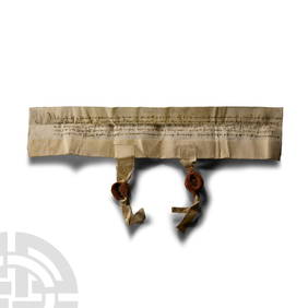
Medieval Henry VI Period Somerset Vellum Manuscript Letter of AttorneyTimeLine Auctions Ltd.4.5(183)See Sold PriceMar 07, 2024
Vintage County Map Of NY State Plate EngravingThe Benefit Shop Foundation Inc.4.3(2.9k)See Sold PriceFeb 28, 2024
Portfolio of 15 County Maps by Robert Morden (English 1650-1703)Nadeau's Auction Gallery4.7(401)See Sold PriceFeb 24, 2024
[ENSLAVEMENT & ABOLITION]. Partly-printed "List of Taxable Property within the District of James D.Freeman's | Hindman4.4(1.6k)See Sold PriceFeb 27, 2024
[ENSLAVEMENT & ABOLITION]. A group of 4 documents identified to the Carr and Tebbs families ofFreeman's | Hindman4.4(1.6k)See Sold PriceFeb 27, 2024
WHO FRAMED ROGER RABBIT (1988) - Series of Hand-Painted Roger Rabbit Screen-Test Animation CelsPropstore4.2(6)See Sold PriceMar 12, 2024
2.7/8" Quad Concave Gorget, Williams County Ohio, Nicely Banded Slate, Ex Bill Kacer FamilyHeartland Artifact Auctions Inc4.7(780)See Sold PriceMar 10, 2024


![[MAPS & ATLASES]. SEALE, Richard William. A Map of (1 of 1)](https://p1.liveauctioneers.com/197/168691/85058396_1_x.jpg?height=282&quality=70&version=1589391499)


![[Map] Seale, Richard. Map of North America (1 of 4)](https://p1.liveauctioneers.com/3532/91776/46880446_1_x.jpg?height=282&quality=70&version=1469669287)

![Middle East.- Seale (Richard William) Arabia, [1764]. (1 of 1)](https://p1.liveauctioneers.com/5458/147572/74578930_1_x.jpg?height=282&quality=70&version=1565275641)


![[MILITARY ARCHITECTURE] Six plans by Seale (1 of 1)](https://p1.liveauctioneers.com/1124/187577/94368876_1_x.jpg?height=282&quality=70&version=1607095126)


![[ENSLAVEMENT & ABOLITION]. Partly-printed "List of Taxable Property within the District of James D. (1 of 3)](https://p1.liveauctioneers.com/197/319238/171468026_1_x.jpg?height=282&quality=70&version=1707520367)
![[ENSLAVEMENT & ABOLITION]. A group of 4 documents identified to the Carr and Tebbs families of (1 of 11)](https://p1.liveauctioneers.com/197/319238/171468034_1_x.jpg?height=282&quality=70&version=1707520367)