Poster "Les jardins de Paris", illustrated map and plan of Paris with its parcs, gardens, monuments,Proverde Auctions4.3(3)See Sold PriceFeb 28, 2024
WEST CENTRAL AFRICA. Congo Angola Gabon Cameroon Sao Tome. MALLET 1683 old mapJasper524.5(9.8k)See Sold PriceFeb 28, 2024
SoldPictorial map of Japan 1886Heading: (Japan) Author: Sagano, Hikotaro Title: Dai Nihon zenzu (The picture of the Great Whole Map of Japan; Provinces in the Japanese Empire, including Korea) Place Published: Japan Publisher:SaganSee Sold Price
Japan. Gulf of Osaka. Hiogo and Osaka.Title/Content of Map: Japan. Gulf of Osaka. Hiogo and Osaka. Date: 1886-06-01 Cartographer: BARTLETT, J. R. Publisher: HYDROGRAPHIC OFFICE. U.S. NAVY Size: 17Height - 22.5Width With two insets. Plan oSee Sold Price
Japan. Gulf of Osaka. Hiogo and Osaka.Title/Content of Map: Japan. Gulf of Osaka. Hiogo and Osaka. Date: 1886-06-01 Cartographer: BARTLETT, J. R. Publisher: HYDROGRAPHIC OFFICE. U.S. NAVY Size: 17Height - 22.5Width With two insets. Plan oSee Sold Price
Osaka, Kobe & Hiogo, Japan With Street Plans 1886Bartlett, J. R. Japan. Gulf of Osaka. Hiogo and Osaka. Lithographed map. Hydrographic Office, U.S. Navy, 1886. 17" x 22 ½" sheet. With two insets. Plan of city of Osaka. Soundings. Scarce.See Sold Price
SoldFramed MapChina and Japan 1886, by Wm. M. Bradley and Bros., 18" x 24" image, 23" x 29.5" framedSee Sold Price
Sold1886 Map of Indian NationsAuthor: Clare Title: 1886 Map of Indian Nations Medium: Ink on Paper Dimensions: 14.5"X11" Description: Map dated 1886 part of Watson's General Atlast. Engraved by I.S. Clare it captures the Indian NaSee Sold Price
SoldTallis, John (Pub) 1852 Map. Japan & Corea. KoreaSteel Engraved Map with Original Outline Hand Color Published 1852-56 by John Tallis, London for "The Universal Pronouncing Dictionary" by Thomas Wright. Drawn & Engraved by John Rapkin. Centre fold aSee Sold Price
SoldMAP, Japan, BellinJapan. Jacques Nicolas Bellin, Carte de l'Empire du Japon pour Servir a l'Histoire Generale des Voyages, from La Harpe's Abrege de l'Histoire Generale des Voyages, 1752 (dated). Hand Color. This is aSee Sold Price
Sold1886 Map of CharlestonAuthor: Cram Title: 1886 Map of Charleston Medium: Ink on Paper Dimensions: 11"X14.5" Map of Charleston dated 1886. Engraved and printed by George Cram in Chicago. Out of all the city maps, CharlestonSee Sold Price
Sold1886 Map of MontanaAuthor: Cram Title: 1886 Map of Montana Medium: Ink on Paper Dimensions: 21"X13.5" Map of Montana dated 1886. Printed and published by George Cram in Chicago. Part of his World Atlas. Key lower left.See Sold Price
Sold1886 Map of the Chinese EmpireAuthor: Blackie Title: 1886 Map of the Chinese Empire Materials: Ink on Paper Size/Dimensions: 21"X15" Description: Map of the Chinese Empire dated 1886. Part of the Imperial Atlas of Modern GeographySee Sold Price
SoldTEXAS C. 1886 MAP, PART OF INDIAN TERRITORYFramed map of Texas, c. 1886, showing counties with an inset for the Panhandle and a portion of the Indian Territory (Cheyennes, Arrapahoes), sight: 11.75"h, 17"w, overall: 21.75"h, 25.75"w, 4.25lbs SSee Sold Price
Sold1886 Map of BirminghamTitle: 1886 Map of Birmingham Author: Cram Medium: Ink on Paper Dimensions: 14.5"X11.5" Description: Map of Birmingham dated 1886. Engraved and published by George Cram in Chicago. Detailed explanatioSee Sold Price
Sold1886 Map of the Philippine IslandsAuthor: Blackie Title: 1886 Map of the Philippine Islands Medium: Ink on Paper Dimensions: 10.5"X15" Map of the Philippine Islands dated 1886. Part of the Imperial Atlas of Modern Geography. This wasSee Sold Price
Sold1886 Map of Oklahoma and the Indian TerritoryAuthor: Watson Title: 1886 Map of Oklahoma and the Indian Territory Medium: Ink on paper Dimensions: 14.5"X11" Map of Oklahoma and the Indian territory dated 1886. Part of Watson Universal Atlas publiSee Sold Price
Sold1886 Map of LondonAuthor: Cram Title: 1886 Map of London Medium: Ink on Paper Dimensions: 21.5"X14.5" Map of London dated 1886. Engraved and published by George Cram in Chicago. Part of his World Atlas. Double folio maSee Sold Price
Sold1886 Map of ItalyAuthor: Watson Title: 1886 Map of Italy Medium: Ink on Paper/Glass/Wood Dimensions: 17"X20" Map of Italy from Watson's Illustrated Atlas of the World dated 1886. Published by Iliff&co. in Chicago. MapSee Sold Price
Sold1886 Map of CubaAuthor: Cram Title: 1886 Map of Cuba Medium: Ink on Paper Dimensions: 22"X14.5" Map of Cuba dated 1886. Engraved and published by George Cram in Chicago. Map key located middle left. Upper right inserSee Sold Price
Sold1886 Map of Porto RicoTitle: 1886 Map of Porto Rico Author: Cram Medium: Ink on Paper Dimensions: 22.5"X14.5" Description: Map of Porto Rico dated 1886. Engraved and published by George Cram in Chicago. Double folio map wiSee Sold Price
Sold1886 Map of BermudaAuthor: Watson Title: 1886 Map of Bermuda Medium: Ink on Paper Dimensions: 14.5"X11.5" Map of Bermuda dated 1886. Part of Watson's Standard Atlas of the World. Published in Chicago. Key upper middle.See Sold Price
1886 Map of Austria-HungaryTitle: 1886 Map of Austria-Hungary Author: Watson Medium: Ink on Paper Dimension: 15"X12" Description: Map of Austro-Hungary dated 1887. Part of Watson's Illustrated Atlas published in Chicago. Map keSee Sold Price
SoldAntarctic South Pole Drift Ice Limit 1886 MapAntarctic. South Pole. Drift Ice Limit. Wilkes Graham Victoria Land, 1886 Map. Title/content of Map: 'south Polar Chart' date Printed: 1886 image Size: Approx 15.0 X 21.0cm, 6 X 8.25 Inches (medium) tSee Sold Price
Sold1886 Map of ColoradoTitle: 1886 Map of Colorado Author: Cram Medium: Ink on Paper Dimensions: 14"X11" Description: Map of Colorado dated 1886. Printed and published by George Cram in Chicago. Part of his World Atlas. KeySee Sold Price
SoldMagnificent 1886 Map of Pairs on Linen PlusExcellent lot of old Parisian maps and tour guides with the best being is a large 32x42" map of Paris and the surrounding 30 kilometers plus two other fold out maps and an early tour guide. Est.$200-3See Sold Price
Occupied Japan Lacquer Book Cover w. chip-carved map/Japan on back Buddha on FrontThe Buddha Gallery4.4(29)See Sold PriceMar 13, 2024
Attributed Leonard Foujita W/C Self Portrait in Studio with CatHeritage Gallery Auctions4.4(56)See Sold PriceMar 10, 2024
After Leonard Foujita Etching titled Hear - Speak - See - No EvilHeritage Gallery Auctions4.4(56)See Sold PriceMar 10, 2024
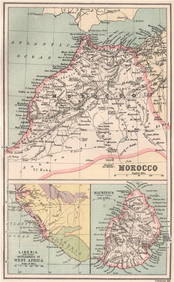
MOROCCO LIBERIA & MAURITIUS. Sierra Leone. BARTHOLOMEW 1886 old antique mapJasper524.5(9.8k)See Sold PriceFeb 28, 2024
NILE VALLEY. Upper & Lower. Egypt Sinai Nubia Sudan Abyssinia. BLACKIE 1886 mapJasper524.5(9.8k)See Sold PriceFeb 28, 2024
Central Africa. Congo Zambia Tanzania Kenya Mozambique. BARTHOLOMEW 1886 mapJasper524.5(9.8k)See Sold PriceFeb 28, 2024
MAGHREB. North Africa. Marocco Algeria and Tunis. BLACKIE 1886 old antique mapJasper524.5(9.8k)See Sold PriceFeb 28, 2024
Showers of Red Dust. Africa. Sahara 1886 old antique vintage map plan chartJasper524.5(9.8k)See Sold PriceFeb 28, 2024
EARLY COLONIAL WEST AFRICA. Empires of Sokoto Gando Mas.Tribes.Fellatah 1886 mapJasper524.5(9.8k)See Sold PriceFeb 28, 2024
(1886-1912) Japan Silver Yen Mutsuhito Era (Chopmarked)Pacific Global Auction3.9(274)See Sold PriceFeb 27, 2024
Blackie (Pub) 1882 Folio Map. Chinese Empire and JapanAlbion Auctions4.6(341)See Sold PriceMar 01, 2024
Perry, Matthew C. 1856 Large Map. Shah Bay, Lew Chew I. JapanAlbion Auctions4.6(341)See Sold PriceMar 01, 2024