Claude Monet French 1840 - 1926 Oil on canvas Painting Impressionism Renoir Manet Pissarro Era.International Art Auction Gallery4.5(154)See Sold PriceFeb 24, 2024
Antique American Hudson River School Sunset Landscape Framed Original Oil PaintingCurated Gallery Auctions4.6(120)See Sold PriceFeb 25, 2024
Robert William Wood (1889 - 1979) Texas BluebonnetsPremier Auction Galleries4.3(329)See Sold PriceMar 09, 2024
BIRGER SANDZEN (1871-1954) COLORADO OIL ON CANVAS 1936Soulis Auctions4.8(953)See Sold PriceFeb 24, 2024
George Adomeit (American 1879-1964) CAPE COD LandscapePremier Auction Galleries4.3(329)See Sold PriceMar 09, 2024
Vincent Van Gogh Dutch 1853-1890 Oil on canvas. Paul Gaugin, Cezanne, Degas EraInternational Art Auction Gallery4.5(154)See Sold PriceFeb 24, 2024
Renaissance Old Master Altarpiece Adoration Magi Oil Painting Christ Child Virgin Mary Wise MenHess Fine Auctions4.5(197)See Sold PriceMar 02, 2024
19TH C GERMAN OIL PAINTING BY EMIL ZSCHIMMER C 1872Antique Arena Inc.4.5(852)See Sold PriceFeb 24, 2024
JOHN CONSTABLE ANTIQUE ENGLISH CLOUDS OIL PAINTINGAntique Arena Inc.4.5(852)See Sold PriceFeb 24, 2024
ATTRIBUTED TO GILBERT STUART (MA/RI/UK, 1755-1828)Thomaston Place Auction Galleries4.4(386)See Sold PriceFeb 24, 2024
Pablo Picasso Spanish 1881-1973 Oil On Canvas Painting Dali Magritte Braque Juan GrisInternational Art Auction Gallery4.5(154)See Sold PriceFeb 24, 2024
ATTRIB Francisco Miralles Y Galup (Spain,France,1848-1901) oil painting antiqueBroward Auction Gallery4.8(277)See Sold PriceMar 10, 2024
AMERICAN SCHOOL (Early 20th c) Two WorksJohn McInnis Auctioneers,LLC4.6(502)See Sold PriceFeb 25, 2024
Marc Chagall-Limited Edition -Paris Opera Ceiling after ChagallArt Legacy Auctions4.5(217)See Sold PriceFeb 24, 2024
Sold1854 JACOB MONK WALL MAP OF N. AMERICA & U.SSHOWING ONE OF THE MOST INTERESTING AND ATTRACTIVE 19TH CENTURY WALL MAPS OF NORTH AMERICA . PUBLISHED 1854 BY JACOB MONK , THIS LARGE AND BEAUTIFUL WALL MAP DETAILS MUCH OF NORTH AMERICA FROM THE SOUSee Sold Price
SoldJOHN RAPKIN (English 19th Century) and J. MARCHANTJOHN RAPKIN (English 19th Century) and J. MARCHANT (Australian 19th Century) A HAND COLORED MAP, "North America," CIRCA 1851, the map of North America with hand colored outlines of each country and stSee Sold Price
SoldRare 1st ed. map of world diseases, c1848World map showing the spread of diseases across the globe in mid-19th century. Three inset maps show diseases in North America, the spread of cholera throughout the world and South Africa. Charts andSee Sold Price
SoldLot of 12 Early 19th Century MapsMostly by Jeffery's. Depicting the East Indies, Germany and surround, Asia, Africa, "Turky in Asia" , Italy and surround, Spain & Portugal, early North America, France, South America, Europe, and HungSee Sold Price
Sold5V US Reference HISTORY OF MAPS OF NORTH AMERICA USA5V US Reference HISTORY OF MAPS OF NORTH AMERICA USA Cartography Books-On-Books 19th Century Alabama Dr John Mitchell Atlas Joseph Scott Southeast Early Maps Annotated Checklist Printed Manuscript LocSee Sold Price
SoldMaps 19th Century Mixed Lot of 15Incl Asia Minor, Asia, Europe, Denmark, Manchester, Australia, Canada, USA, North America, UK, Germany, World Rainfall & Vegetation, Syria, Europe, Asia, and Nubia/Abyssinia. Lot of 15 sheets of MapsSee Sold Price
SoldTWO 19TH CENTURY ENGRAVINGS AFTER KARL BODMERCirca 1832-1834 The two bookplates from the Maximilian, Prince of Wied's, Travels in the interior of North America atlas, 1832-1834, titles Mandan Women and Dance of the Mandan Indians, each is publisSee Sold Price
SoldLate 18th Century Maps of North America, Lot of TwoLate 18th Century Maps of North America, Lot of Two Two maps of North America, including: English, ca. 1776. An accurate Map of the present Seat of War, between Great-Britain [sic] and her Colonies inSee Sold Price
SoldLate 17th-Early 18th Century Maps of North America, LotLate 17th-Early 18th Century Maps of North America, Lot of Two Two maps of North America, including: English, late 17th-early 18th century. Robert Morden (British, 1650-1703), America. Title identifieSee Sold Price
SoldA rare Lakota Sioux Horse Dancing Stickdating: 19th Century provenance: North America, Wooden, embossed with a horse's head, the other end hoof-shaped, slightly painted. The head decorated with a horse cross, leather bridle with pendant deSee Sold Price
SoldLAURIE & WHITTLE BRITISH 18TH CENTURY MAP OF NORTHLAURIE & WHITTLE BRITISH 18TH CENTURY MAP OF NORTH AMERICA, hand-colored, title in cartouche to upper right corner "A NEW AND CORRECT MAP / OF THE / BRITISH COLONIES IN NORTH AMERICA / Comprehending /See Sold Price
SoldA very scarce decorated bridle without bit of a Navajodating: Late 19th Century provenance: North America, In original leather, with heavy, silver mounts, oval, engraved side studs, crownpiece with a pendant, decorated with a turquoise, cabochon stone. lSee Sold Price
SoldAn extremely rare iron bit of the Navajo Indian tribedating: 19th Century provenance: North America, In iron, with 'U'-purchase, provided with copper rolls, big ring in the front part. Short, 'U'-purchases and long final crossbar, all complete with chaiSee Sold Price
SoldDe Vaugondy: Amerique SeptentrionaleMap: Amerique Septentrionale Maker/Publisher: De Vaugondy, Robert, Paris Publishing Date: 1748 Size: 6.25 x 7.75 inches Interesting mid-18th century map of North America, published by Robert De VaugonSee Sold Price
SoldA Red indian's saddleA Red indian's saddle dating: 19th Century provenance: North America, Wooden, leather-covered. Small parts missing. Scarce. length 45 cm.See Sold Price
SoldFour Late 18th Century Regional Maps of North Americafrom his Histoire General des Voyages, 1757, copperplate engravings with outline color, the maps variously depicting New England, the Chesapeake Bay, the Carolinas and Georgia, Louisiana and Florida.See Sold Price
SoldAn interesting lot of five pairs of spursdating: 19th/20th Century provenance: North America, A pair of big shape, the neck provided with five big disk-rowels, two of which are dented, a pair richly decorated with silver-inlaid geometrical mSee Sold Price
Sold1761 MAP OF NORTH AMERICA BY ROCQUE18th century map GENERAL MAP OF NORTH AMERICA 1754-1761 by John Rocque, London by A. Drury, 2 part map, 35.5 x 36 inches, good condition.See Sold Price
Sold19th Century Religious Scrimshaw Whale ToothNorth America; 19th century. Sailor-made scrimshawed whale's tooth depicting the Annunciation and The Good Shepard, Jesus, and Mary. Dimensions Length: 4" (10 cm) Width: 2" (5 cm) Provenance Museum MaSee Sold Price
Sold19th Century Scrimshaw Whale ToothNorth America; 19th century. Scrimshaw whale's tooth depicting the whaling ship W. R. Grace on one side, and on the other a young beauty holding a parasol. Dimensions Length: 4" (10 cm) Width: 2" (5 cSee Sold Price
SoldWhale Bone Sailor Made Figural Pipe TamperNorth America; 19th century. A lovely carved and scrimshawed whale bone pipe tamper in the form of a woman's leg, engraved with stocking and laced boot. The tamper end showing a sailing ship at sea. DSee Sold Price
Sold19th C. American Buffalo Horn Scrimshawed VesselNorth America, 19th century CE. An antique buffalo horn vessel finely engraved with mesmerizing scenes of female figures or goddesses and flowering foliage, all skillfully delineated via the scrimshawSee Sold Price
Sold19th Century Scrimshaw Whale ToothNorth America; 19th century. Sailor made scrimshaw whale's tooth depicting the whaling ship Horatio on one side and a whaling hunt scene on the other. Dimensions Length: 4 5/8" (11.7 cm) Height: 2" (5See Sold Price
Sold19th C. Wonderful Cast Bronze Human SkullEurope or North America, ca. 19th century CE. A cast bronze replica of a petite upper portion of a human skull - from a slight individual, or perhaps scaled down from a real skull (it is not a child'sSee Sold Price
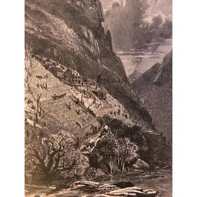
19thc North Carolina Engraving, Farm On The French Broad RiverConnoisseur Auctions4(333)See Sold PriceMar 02, 2024
1849 Mitchell School ATLAS 24 MAPS America Holy Land France Africa Egypt AsiaSchilb Antiquarian Rare Books4.8(421)See Sold PriceMar 31, 2024
1855 NOTES ON CENTRAL AMERICA by E. G. Squier antique w/ MAPSJasper524.5(9.8k)See Sold PriceFeb 27, 2024
1822 MAP of SOUTH AMERICA GEOGRAPHICAL STATISTICAL HISTORICAL antique 17.5x 22"Jasper524.5(9.8k)See Sold PriceFeb 27, 2024
1822 MAP of NORTH & SOUTH AMERICA GEOGRAPHICAL STATISTICAL HISTORICAL antiqueJasper524.5(9.8k)See Sold PriceFeb 27, 2024
1760 MAP CARTE PARTICULIERE DE L'ISLE DE JUAN FERNANDES antique Robinson CrusoeJasper524.5(9.8k)See Sold PriceFeb 27, 2024
1738 RUSSIA SIBERIA & GREAT TARTARY Description illustrated ANTIQUE in ENGLISHJasper524.5(9.8k)See Sold PriceFeb 27, 2024
West Africa. Sahara caravan routes. Tribes Kingdoms Empires. LIZARS 1842 mapJasper524.5(9.8k)See Sold PriceFeb 28, 2024
Afrique Ancienne. Ancient North Africa. MALTE-BRUN c1871 old antique map chartJasper524.5(9.8k)See Sold PriceFeb 28, 2024
Two Hand-Colored 19th Century Maps of New Orleans and Louisiana, Larger- H.- 12 1/2 in., W.- 15 1/2Crescent City Auction Gallery4.3(229)See Sold PriceMar 08, 2024
Early USA Ceremonial Fraternal Sword, Foster Son & Co.Artemis Fine Arts4.8(1.4k)See Sold PriceFeb 26, 2024
Early / Signed Chromolithograph - Venetian LandmarksArtemis Fine Arts4.8(1.4k)See Sold PriceFeb 26, 2024
JJ Audubon 19C 3 Vols Quadrupeds North American Bowen Illus Full Leather v1-3 Gilt SetHess Fine Auctions4.5(197)See Sold PriceMar 02, 2024